



VR intersects 317 m at 0.77% CuEq starting at surface, above 419 m of 0.48% CuEq, in 881 m drill hole of continuous polymetallic stockwork veining at New Boston Porphyry-Skarn project, Nevada
0.77% CuEq* over 317m starting at surface;
0.48% CuEq* over 419 m starting at 460 m, including:
0.98% CuEq* over 31 m at 604 m in diorite porphyry intrusion and skarn, and;
33.4% CuEq* on 1.48% WO3, 0.32% Cu & 427 g/t Ag in a two metre interval in garnet marble skarn at 535m, above the diorite porphyry;
0.35% CuEq* over 7 m incl. mineralized granite porphyry at 858 m at bottom of hole.
VANCOUVER, British Columbia, Aug. 26, 2026 (GLOBE NEWSWIRE) -- VR Resources Limited (“VR” or the “Company”, TSX.V: VRR, FSE: 5VR0; OTCQB: VRRCF) is pleased to announce geochemical results from drill hole NB26-003 completed through continuous veining with sulfide to 881m depth (2,892 ft) in the western part of its New Boston moly-copper-tungsten-silver-zinc porphyry-skarn mineral system located just off Highway 95 in west-central Nevada.
From Dr. Michael Gunning, Chief Executive Officer of the Company, “The new data from NB26-003 show us nearly continuous mineralization in moly, copper, tungsten, silver and zinc in complex and intense polyphase veining that is continuous across 2,892 ft of drill core, and starts with 3.95% CuEq* at surface (see Photo 1).
Moly-tungsten mineralization with copper characterizes the upper 317 m mineral interval at 0.77% CuEq*, and copper-moly mineralization characterizes the 419 m interval at 0.48% CuEq* below, which is centered on a mineralized diorite porphyry intrusion at 0.98% CuEq* that is a new and important discovery for the New Boston porphyry-skarn system overall.
New Boston is a polymetallic mineral system. Tungsten mineralization starts at surface and is present to 550 m depth, with sample values up to 2.3%. There is moly across 2,892 ft of drill core, with sample values up to 1.0%. Copper mineralization is nearly continuous and strengthens down-hole, with sample values up to 0.73%. Silver is present across the 2.1 km strike of sheeted veins on surface at New Boston (see Figure 1), and there is low grade silver throughout NB26-003, with values up to 830 g/t over 1m in high grade skarn zones.
Alteration, veining and mineralization effects all rock types in the drill hole, from top to bottom, and the system is open at depth. NB26-003 was ended at 881 m because the hole was unstable; there is copper and moly mineralization at the bottom of the hole in a strengthening potassic alteration facies (Photo 14).
Drill hole NB26-003 demonstrates a kilometer-scale vertical dimension to the polymetallic mineral system at New Boston, to match the 2.1 km strike of mineralized sheeted veins exposed on surface.
Drill hole NB26-003 is literally a handful of kilometers away from state highway, grid power and rail infrastructure (see panoramic field photo in Figure 1).
Permitted drill sites are shown in Figure 2. They are amongst a network of historic drill roads and trails visible in Figure 1, and will facilitate cost-effective follow-up drilling planned for the NB26-003 discovery.
There is current exploration on tungsten systems of similar geologic age and setting nearby to the southeast at Pilot Mountain, and in southwest Idaho in the Thompson creek camp.New Boston stands out for its polymetallic composition, with critical metals in moly, copper, silver and zinc in addition to tungsten, all on the Strategic Metals list in Washington where the political focus is on domestic critical-metal supply and resilience. We look forward to providing further details as we advance on the results achieved in this drill hole.”
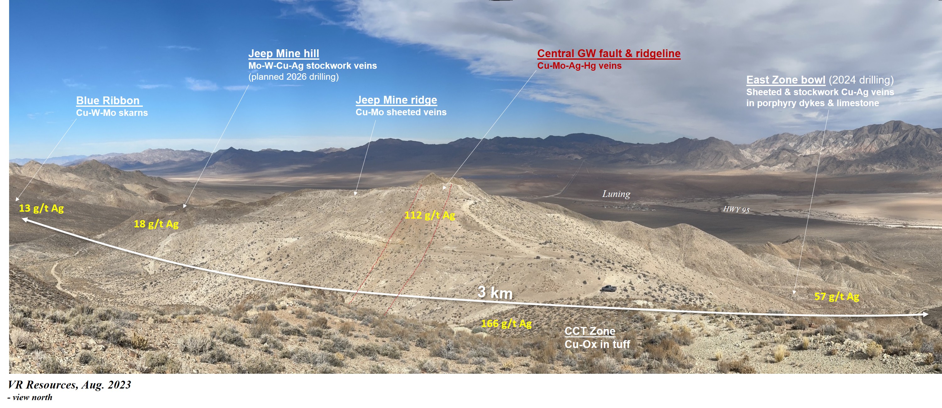
Figure 1. New Boston has scale. Sheeted dykes and sheeted and stockwork veins with tungsten, moly, copper and silver are exposed on surface over an east-west strike length of more than 3km. Yellow text highlights, for example, silver content in surface grab samples of veins by VR. Conductivity anomalies at East Zone were drilled by VR in 2024. Co-spatial conductivity - IP chargeability anomalies at Jeep Mine shown in Figures 2 & 3 were the target for NB26-003 completed in June, 2026. Local infrastructure is strong at New Boston.
Table 1. Summary of mineral intervals, drill hole NB26-003+.
| Hole | From (m) | To (m) | Length (m) | CuEq* (%) | Cu (%) | MoS2(%) | WO3(%) | Ag (g/t) |
| NB26-003 | 0 | 317 | 317 | 0.77 | 0.04 | 0.11 | 0.02 | 1.5 |
| including | 40 | 124 | 84 | 1.78 | 0.03 | 0.18 | 0.07 | 1.4 |
| NB26-003 | 460 | 879 | 419 | 0.48 | 0.07 | 0.05 | 0.01 | 3.8 |
| including | 528 | 544 | 16 | 4.52 | 0.04 | 0.01 | 0.20 | 53.9 |
| also including | 535 | 537 | 2 | 33.43 | 0.32 | 0.00 | 1.48 | 427 |
| including | 561 | 691 | 130 | 0.44 | 0.11 | 0.10 | 0.00 | 2.5 |
| and also including | 604 | 635 | 31 | 0.98 | 0.19 | 0.27 | 0.00 | 3.6 |
| including | 858 | 865 | 7 | 0.35 | 0.08 | 0.05 | 0.01 | 2.0 |
+ The two broad mineral intervals defined in Table 1 are qualitative, based on integrated analytics on geology, geochemistry and hyperspectral mineral data, but they are subjective in nature and do not imply grade or thickness. They are used to underscore broad zonation in metals and mineral alteration as described in the previous and following sections, and they provide context for variations observed in the continuous polyphase veining through the 881 m drill hole. There is no unaltered drill core in NB26-003; drill core in between the two broad mineral zones has equally intense veining and alteration as the mineral zones themselves, but carries less sulfide.
* Copper Equivalent ( "CuEq ") is a mathematical compositional average for a single sample, or sample interval, based on comparative metal prices. It is used in polymetallic systems for illustrative purposes only; the calculation is not economic in nature. For example, it does not consider metal recovery, and assumes the same recovery for all metals. By convention, the equivalence reported here uses metal prices discounted from current, at market and/or near-term metal prices. Metal prices used in the calculation include a tungsten price of US$1900/MTU, a molybdenum price of US$20.00/lb, a copper price of US$4.50/lb and a silver price of US$35.00/Oz, according to the formula: CuEq (%) = Cu (%) + [ MoS₂ (%) × 0.5994 × 22.0462 × US$20.00 + Ag (g/t) ÷ 31.1035 × US$35.00 + WO₃ (%) × US$1,900 ] ÷ ( 22.0462 × US$4.50 ).
Geologic Context for Polymetallic Mineralization and Broad Mineral Intervals
Near-Surface. The drill core rubble shown in Photo 1 from the anchor hole for the drill on the pad was sampled and it carries 3.95% CuEq* on 0.43% MoS2, 0.09% Cu, 0.14% WO3, 4.0 g/t Ag, consistent with the 317 m interval at 0.77% CuEq* at the top of the hole, starting at surface, with up to 0.5% Cu with 29g/t Ag at 65 m, 0.42% WO3 at 96 m, and 0.27% Cu with 56 g/t Agat 186m in individual one metre samples,
Vertical Extent. NB26-003 did not see the bottom of the mineral system. There is 0.36% CuEq* over 7 m at 858 m associated with a sulfide-bearing granite porphyry (Kqbp) shown in Photo 13. Further below, near the bottom of the hole, there is 0.1% Cu, 0.09% MoS2, 3.2 g/t Ag at 876 m, in a high temperature, Mg-rich dolomitized wollastonite marble with a high intensity of sub-vertical veinlet streams of hydrothermal k-spar with vein margins of clinopyroxene and magnetite, similar to that shown at 865 m in Photo 14. That sample is 877 m below the anchor hole sample at surface carrying 3.95% CuEq*.
Porphyry intrusions. There are no less than 21 occurrences of variably mineralized porphyry intrusions in NB26-003 (see log Figure 4). First appearance is at 2.7 m depth, and last appearance is 865 metres below at 868 m, just 13 m from the bottom of the hole. Quartz monzonite / dacite porphyry is dominant in the upper part of the hole, diorite porphyry in the middle of the hole, and biotite granite porphyry in the lower part of the hole.
The mineralized diorite porphyry intrusion at 610 m is a new and important discovery for the New Boston skarn and porphyry mineral system overall. It is not evident on surface, and not shown on historic maps or data compilations. It is sulfide laden, as disseminated grains and sinuous sulfide veinlets. It carries 0.98% CuEq* over 31mwhich includes local marble breccia zones, with up to 1.58% MoS2 and 0.4% Cu in one-metre sample intervals in the dyke interior (see Photo 6) and 0.5% Cu and 0.18% MoS2 and 11 g/t Ag for 1.52% CuEq* over one metre at the lower contact.
The 31 m diorite porphyry is central to a broader zone of 130 m at 0.44% CuEq*, including mineralized country rock both above and below the intrusion. Marble breccia cemented by sulfide at 650 m in the lower part of the interval contains one metre samples with up to 0.73% Cu, 0.38% MoS2, 0.13% Zn and 16 g/t Ag.
A similar porphyry phase at 572 m with a heavy dissemination and vein-style sulfide content carrying 0.18% Cu and 3.6 g/t Ag is shown in Photo 5.
High grade skarn mineralization adjacent to diorite porphyry. The high-crystallinity white marble and garnet skarn above the diorite porphyry hosts a one-metre sample interval of 2.85%WO3, 0.62% Cu and 830 g/t Ag at 535 m that is not unique in context or character to marble skarn developed throughout the upper two thirds of the hole, and on surface more generally where grades of this magnitude are evident in grab samples from across the 3 to 4 km strike of the system. The potential of this interval directly, or potentially others like it within the overall IP chargeability envelope will be a focus of follow-up drilling.
Lateral extent. For lateral extent potential of the mineralization in NB26-003, the following points are relevant:
- The 12 mV/v IP chargeability envelope shown in Figure 2 is in the order of 1,000 m across, and NB26-003 is the only deep hole with complete mineral data in that volume that the Company is aware of.
- There is along-strike potential for the 317 m interval of 0.77% CuEq* starting at surface. This mineralization is associated with quartz-garnet stockwork veining in quartz monzonite / dacite porphyry sills in limestone and interbedded tuffaceous siltstone that are continuous for some 750 m along strike to the east (Photo 2).
- Drill holes 2,100 m to the east of NB26-003 at East Zone (see Figures 1& 2) carry 319 ft @ 0.14% Cu in NB-1 (1967), 0.24% Cu over 284 ft starting at surface in PNB005C (2010), and 117.6m at 0.10% Cu and 98m at 0.12% Cu in separate limestone skarn intervals in VR’s NB24-002 in 2024. Based on the new results from NB26-003, VR will re-assay the pulps from NB24-002 using the sodium peroxide fusion method in order to determine an accurate polymetallic grade including Mo, W and Zn, in addition to Cu and Ag.
Description of Information in News Release
Photos 1 through 14 provided in the active link below this paragraph provide an illustration of vein, alteration and mineralization styles in drill core from surface to 865 m depth. Photo 1 is also included after the figures herein, for reference.
http://ml.globenewswire.com/Resource/Download/156178b3-4472-4ad5-9f76-8885b90283bf
As evident in Photos 1 through 14, polyphase veining is continuous through 2,892 ft of drill core, with an array of geometries, compositions and textures. There is no unaltered drill core in NB26-003; drill core in between the two broad mineral intervals defined in Table 1 has equally intense veining and alteration as the mineral zones themselves, but carries less sulfide (e.g. see garnet and pyroxene in spectral alteration log in Figure 4).
The data in Table 1 and Figure 4 are the product of state-of-the-art geochemical techniques at ALS Global facilities, utilizing fusion by sodium peroxide and chemical analysis by ultra - trace level detection by ICP-MS and ICP-ES methods, providing an accurate picture of the polymetallic composition and grade potential at New Boston for the first time in its 60-year exploration history.
Long-wavelength (LWIR) and short-wavelength (SWIR) hyperspectral scanning was completed over the 2,892 ft of drill core at the industry-leading imaging facility of TerraCore Geospectral in Reno, NV, to map alteration minerals and model vertical zonation, as illustrated in Figure 4. The data are yet to be fully processed, but the impact is already obvious. For example, preliminary data for the lower 30 m of the hole indicate hydrothermal veins are cored by potassium feldspar and rimmed by clinopyroxene and magnetite, suggesting that even after 881 m of continuous veining, copper and moly’ mineralization is occurring in a strengthening high temperature potassic alteration.
Context for Drill Targeting
The target for NB26-003 is new, the result of new technology in the 3D-array ground DCIP survey completed by VR in 2023. The co-spatial IP chargeability and conductivity anomalies shown in Figures 2 and 3 were not previously recognized nor drilled during the sporadic historic exploration at New Boston over the past 60 years.
For exploration best practice and ongoing improvement towards the 2026 spring drill program, the inversion models for the state-of-the-art 3D-array DCIP geophysical survey completed in 2023 at New Boston were reviewed in January during the AME Mineral Exploration Conference in Vancouver with the team at Dias Geophysical, a leading provider of geophysical services. Co-spatial and steeply plunging conductivity and IP chargeability anomalies at Jeep Mine were more precisely defined, and subsequently better understood for drill testing as the potential vein and sulfide center of the overall skarn and porphyry system exposed over a 3-4 km strike on surface at New Boston.
Conductivity anomalies at East Zone identified in that same 2023 DCIP survey were drill tested in 2024 in the first leg of VR’s first-pass drilling at New Boston. Copper and silver mineralization were intersected in continuous and intense stockwork veining in more than 1,500 ft of drill core in Hole 002. The drilling in 2026 into the heart of the IP chargeability anomaly and coincident conductivity at Jeep Mine hopes to build upon those results in terms of the polymetallic grade potential of polyphase, stockwork veins with moly’ and tungsten mineralization in addition to copper and silver.
Drill hole NB26-003 is the first deep hole with complete data that the Company is aware of into the southern flank of the Jeep Mine hill during the past 60 of sporadic exploration at New Boston. Initial drilling from 1967 through 1979 established and delineated the overall character and footprint of the mineral system at New Boston, but was reconnaissance in nature, with widely-spaced holes from East Zone bowl through to the northern flank of Jeep Mine hill, and including distal skarns at Blue Ribbon along strike to the west. In 2026, NB26-003 provides a new glimpse into both the vertical scale of the mineral system exposed on surface, its polymetallic grade potential in moly, copper, tungsten, silver and zinc, and the presence of any number of mineralized porphyry intrusions hypothesized but not identified during historic exploration programs.
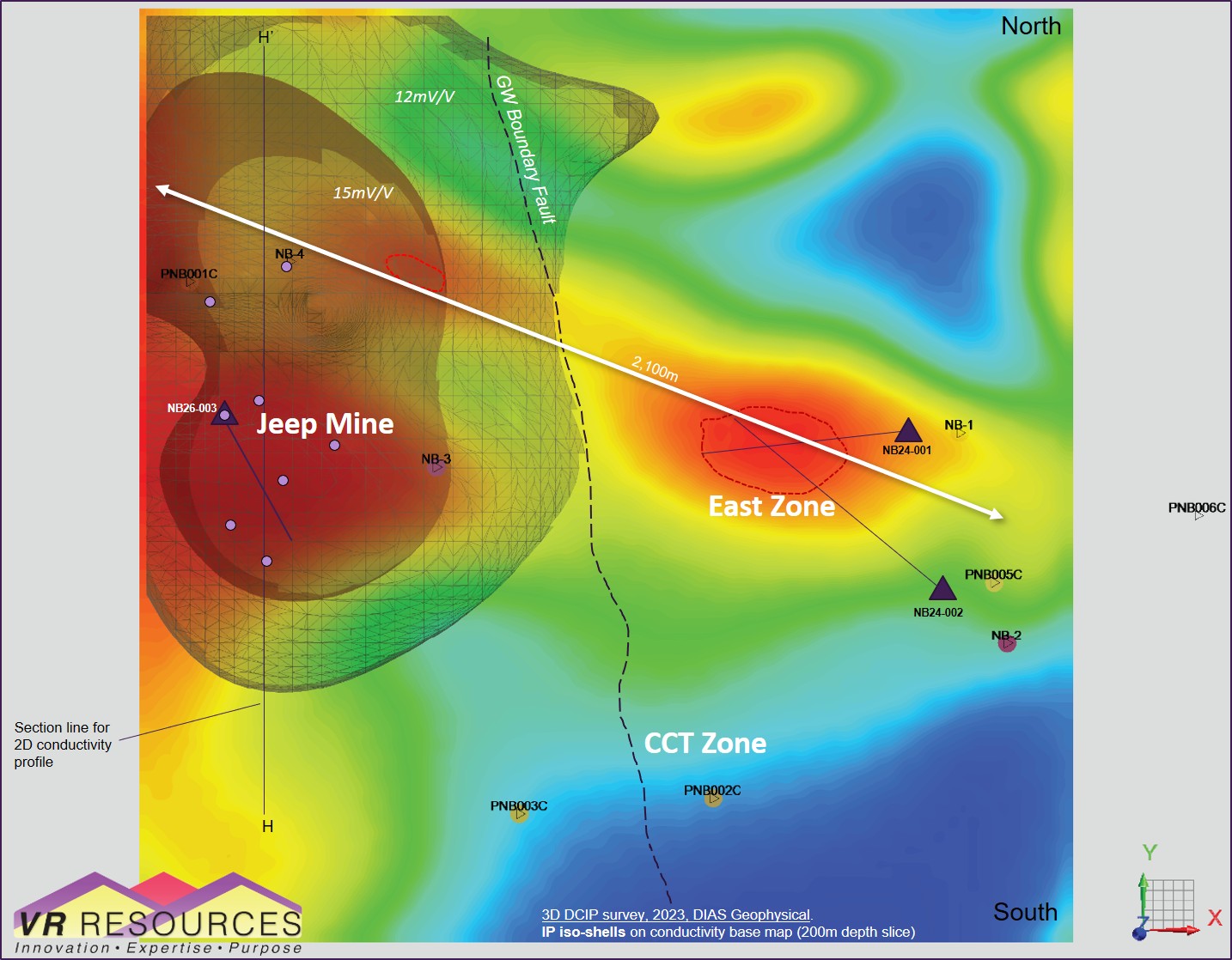
Figure 2. Drill trace for hole NB26-003 on a plan map of the 3D-array DCIP geophysical survey completed at New Boston in 2023. Shown are IP iso-shells on a conductivity base map, 200m depth slice. Chargeability values at the Jeep Mine range from 15–21 mV/V. Blue circles are permitted drill sites. Line H-H’ is the transect line for the conductivity profile shown in Figure 3 below. Mineralized sheeted veins strike for 2,100 m east-west across Jeep Mine through East Zone (see photo in Figure 1).
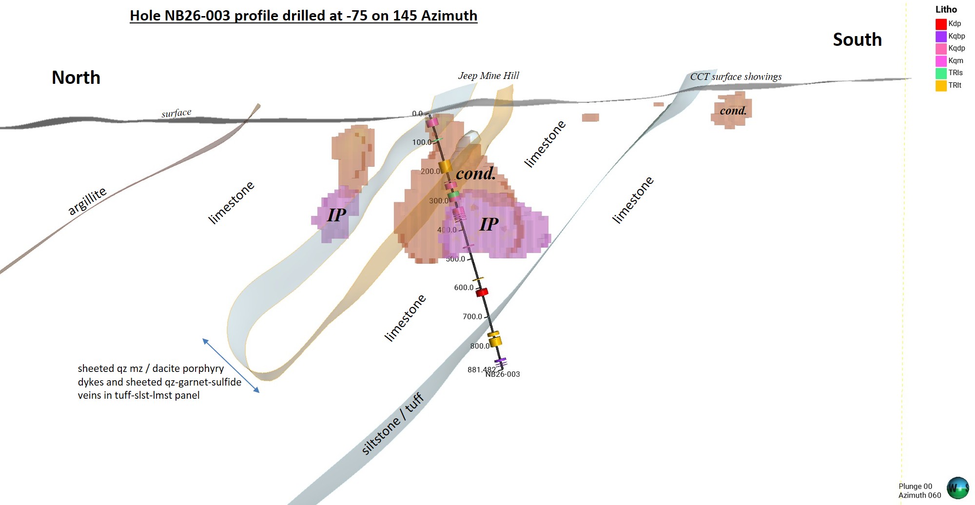
Figure 3. Profile for drill hole NB26-003, completed at -75 towards 145 azimuth, with end-of-hole at 2,892 ft (881 m). There are no less than 21 porphyry sills and/or dykes in the drill hole, shown by the coloured disks. Compositions include quartz monzonite / dacite porphyry, diorite porphyry and biotite granite porphyry. Host rock is limestone (marble) and lesser tuffaceous siltstone of the Triassic Luning formation. Shown are iso-shells for IP chargeability and conductivity anomalies from 3D-array DCIP survey completed by VR in 2023 and shown in plan view in Figure 2.
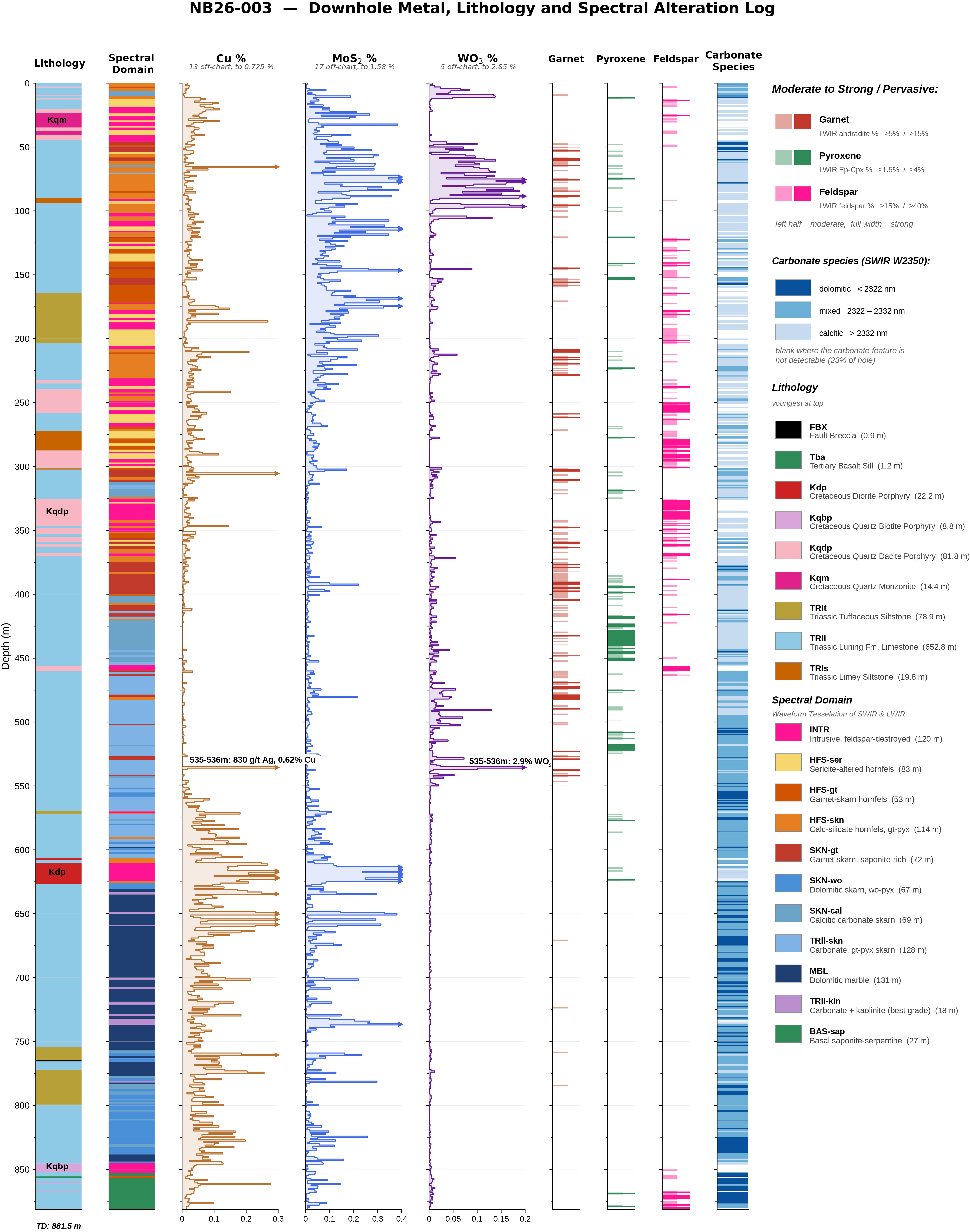
Figure 4. Composite strip log with downhole lithology, copper, tungsten and molybdenum geochemistry, alongside LWIR and SWIR spectral classifications of key alteration and skarn minerals. A spectral domain classification computed through waveform tessellation uses abrupt changes in TerraCore’s spectral data backed by lithogeochemistry to identify unique zones of alteration ranging from high-temperature hornfels-altered siltstones and garnet-altered limestone in the upper hole, to intense dolimitization in the lower part of the hole, including around the copper-rich diorite porphyry at 610 m. Of note is that many hydrothermal alteration assemblages are obscured by a Tertiary hydrothermal argillic overprint related to nearby volcanism.
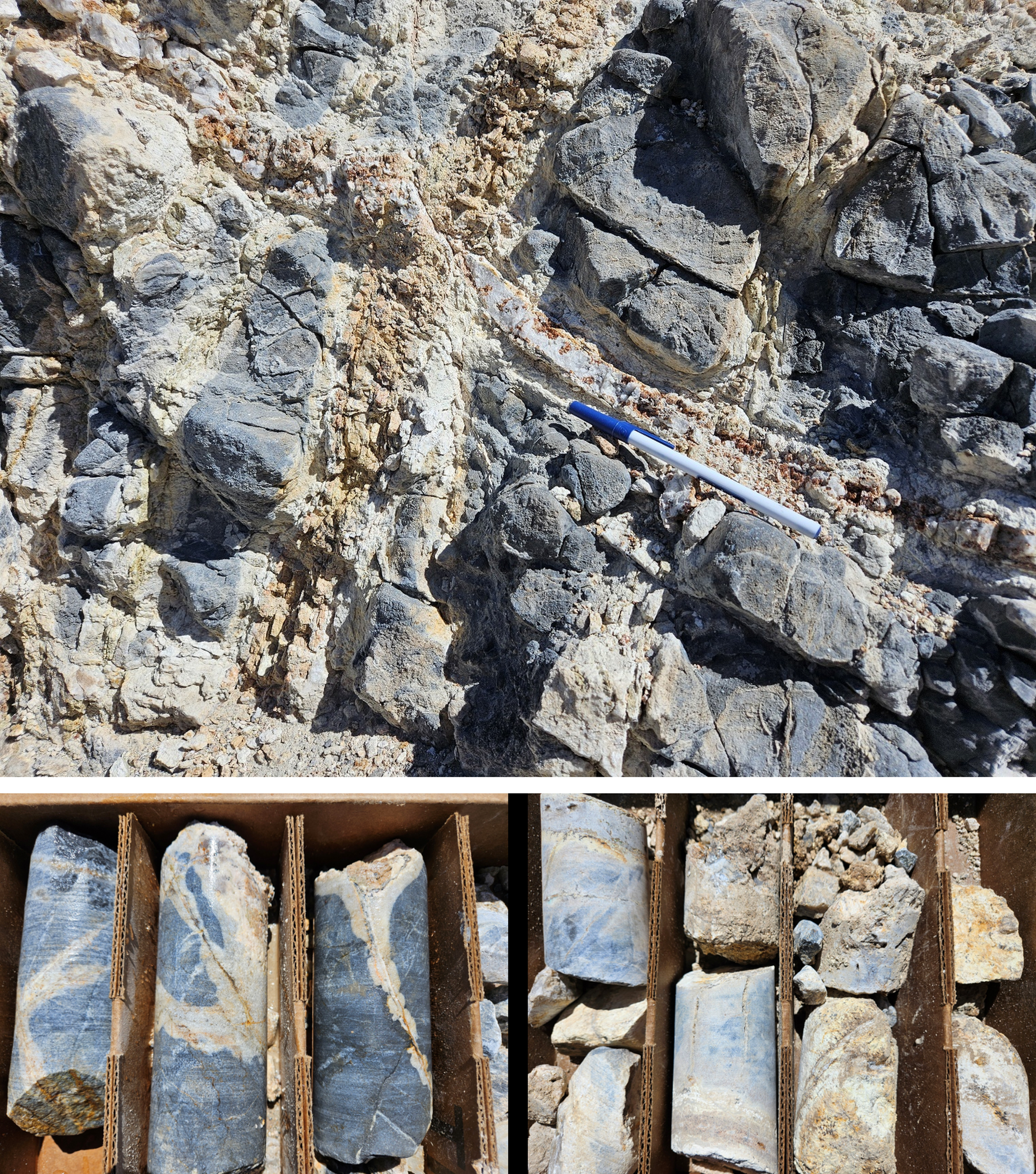
Photo 1:Core rubble sampled from the anchor hole sunk at the drill collar site and outcrop shown in the upper photo for drill hole NB26-003. Note weathered copper sulfide in vein core above pen in photo of quartz-garnet vein stockwork in dark grey but completely recrystallized marble. Results from geochemical analysis by sodium peroxide fusion on drill core rubble are: 3.95% CuEq* on 0.43% MoS2, 0.09% Cu, 0.14% WO3, 4.0 g/t Ag.
Photos 1-14 accompanying this announcement are available at: http://ml.globenewswire.com/Resource/Download/156178b3-4472-4ad5-9f76-8885b90283bf
TECHNICAL INFORMATION
Technical information disclosed by the Company has been prepared in accordance with the Canadian regulatory requirements set out in National Instrument 43-101. Technical information contained in this document, and on the Company’s website, has been reviewed and approved on behalf of the Company by the President & CEO, Dr. Michael Gunning, PhD, P.Geo., a non-independent Qualified Person.
VR submits all surface grab samples and/or drill core samples collected for geochemical analysis from its Nevada-based exploration projects to the ALS Global (“ALS”) facility in Reno, Nevada. Sample preparation is completed in Reno, and ICP analyses are completed in Vancouver, BC.
For drill hole NB26-003, whole core was sampled in order to capture 100% of any potential mineralization present. Samples of <7 kg are crushed so that> 70% passes through a 2mm (10 mesh) sieve. A 250 g split is pulverized by mild steel until >85% passes through a 85μm (85 mesh) sieve. A split of the resulting material sample is taken, and a representative sample pulp is sent to the ALS laboratories located in Vancouver, BC, for chemical analysis. Sample pulp decomposition is by a sodium peroxide fusion and HCl leach process in order to optimize analytical detection of elements in refractory minerals such as scheelite and molybdenite, and analysis is by Inductively Coupled Plasma - Atomic Emission Spectrometry (ICP-AES) and Inductively Coupled Plasma - Mass Spectrometry (ICP-MS) methods for 52 different elements.
Geochemical results are subject to industry-standard and NI 43-101 compliant QAQC sample procedures, including the systematic insertion of sample blanks and certified reference material (CRM) done both externally on the project site by the Company, and internally at the laboratory by ALS, as described by ALS. In the field, blanks and CRM standards were inserted every 40 metres, for the entire drill hole. The CRM used in NB26-003 was CDN-W-4, from CDN Resource Laboratories, Langley, Canada. It is made from a Cretaceous-aged, tungsten-bearing granitic porphyry intrusion located in Yukon Territory, Canada, that is comparable in lithology, setting and mineral deposit character to New Boston. It is certified for copper, moly, tungsten and gold.
The two broad mineral intervals defined in Table 1 are qualitative, based on integrated analytics on geology, geochemistry and hyperspectral mineral data, but they are subjective in nature and do not imply grade or thickness. They are used to underscore broad zonation in metals and mineral alteration as described herein, and they provide context for variations observed in the continuous polyphase veining through the 881 m drill hole. The mineral intervals do not represent true widths. The geometry of the New Boston mineral system is not known. It is not known if true width is an appropriate measure for the New Boston mineral system.
Chemical data reported herein are indicative of composition only, with no economic considerations implied. The chemical compositions reported for composite sample intervals are a straight mathematical averaging over the length of the drill core interval sampled. Copper Equivalent ( "CuEq ") is a mathematical compositional average for a single sample, or sample interval, based on comparative metal prices. It is used in polymetallic systems for illustrative purposes only; the calculation is not economic in nature. For example, it does not consider metal recovery, and assumes the same recovery for all metals. By convention, the equivalence reported here uses metal prices discounted from current, at market and/or near-term metal prices. Metal prices used in the calculation include a tungsten price of US$1900/MTU, a molybdenum price of US$20.00/lb, a copper price of US$4.50/lb and a silver price of US$35.00/Oz, according to the formula: CuEq (%) = Cu (%) + [ MoS₂ (%) × 0.5994 × 22.0462 × US$20.00 + Ag (g/t) ÷ 31.1035 × US$35.00 + WO₃ (%) × US$1,900] ÷ (22.0462 × US$4.50).
A PDF accompanying this announcement is available at http://ml.globenewswire.com/Resource/Download/156178b3-4472-4ad5-9f76-8885b90283bf
ABOUT VR RESOURCES LTD.
VR is an established junior exploration company based in Vancouver. VR evaluates, explores and advances opportunities in copper, gold and critical metals in Nevada, USA, and Ontario, Canada. VR applies modern exploration technologies, in-house experience and expertise in greenfields exploration to large-footprint mineral systems in underexplored areas/districts. The foundation of VR is the proven track record of its Board in early-stage exploration, discovery and M&A. VR owns its projects outright and evaluates new opportunities on an ongoing basis, whether by staking or acquisition.
The reader is referred to the Company’s website at www.vrr.ca for current corporate information and up-to-date summaries of exploration projects illustrated with maps, figures, photos and on-site field videos.
ON BEHALF OF THE BOARD OF DIRECTORS
Dr. Michael H. Gunning
President & CEO
For general information please use the following:
| Website: Email: Phone: | www.vrr.ca info@vrr.ca 778-731-9292 |
CAUTIONARY NOTE REGARDING FORWARD-LOOKING STATEMENTS
This news release contains statements that constitute "forward-looking statements ". Such forward looking statements involve known and unknown risks, uncertainties and other factors that may cause the Company’s actual results, performance or achievements, or developments in the industry to differ materially from the anticipated results, performance or achievements expressed or implied by such forward-looking statements. Forward-looking statements are statements that are not historical facts and are generally, but not always, identified by the words "expects, " "plans, " "anticipates, " "believes, " "intends, " "estimates, " "projects, " "potential " and similar expressions, or that events or conditions "will, " "would, " "may, " "could " or "should " occur. Forward-looking statements in this document include data presentations and interpretations concerning on the geochemical results from the drill hole NB26-003 completed at the New Boston property in Nevada, and all other statements that are not statements of historical fact.
Although the Company believes the forward-looking information contained in this news release is reasonable based on information available on the date hereof, by their nature, forward-looking statements involve assumptions, known and unknown risks, uncertainties and other factors which may cause our actual results, performance or achievements, or other future events, to be materially different from any future results, performance or achievements expressed or implied by such forward- looking statements. Examples of such assumptions, risks and uncertainties include, without limitation, assumptions, risks and uncertainties associated with: general economic conditions; adverse industry events; future legislative and regulatory developments in the mining sector; the Company’s ability to access sufficient capital from internal and external sources, and/or inability to access sufficient capital on favorable terms; mining industry and markets in Canada; the ability of the Company to implement its business strategies; competition; and other assumptions, risks and uncertainties.
The forward-looking information contained in this news release represents the expectations of the Company as of the date of this news release and, accordingly, is subject to change after such date. Readers should not place undue importance on forward-looking information and should not rely upon this information as of any other date. While the company may elect to, it does not undertake to update this information at any particular time except as required in accordance with applicable laws.
Trading in the securities of the Company should be considered highly speculative. All of the Company’s public disclosure filings may be accessed viawww.sedarplus.ca and readers are urged to review them.
Neither the TSX Venture Exchange nor its Regulation Services Provider (as that term is defined in Policies of the TSX Venture Exchange) accepts responsibility for the adequacy or accuracy of this release.
Photos accompanying this announcement are available at:
https://www.globenewswire.com/NewsRoom/AttachmentNg/76655ffd-806f-468e-b5e9-94d7f9eed75d
https://www.globenewswire.com/NewsRoom/AttachmentNg/c1589870-d201-4c5a-b6c9-03325df94d8e
https://www.globenewswire.com/NewsRoom/AttachmentNg/a10037ff-dde5-4f7f-bab8-451c9b289631
https://www.globenewswire.com/NewsRoom/AttachmentNg/59ee070b-4e72-4011-9d8d-8956ef2d497e
https://www.globenewswire.com/NewsRoom/AttachmentNg/0c960672-e460-4c9b-aec8-e29f77a2deb1

© 2026 GlobeNewswire, Inc. All Rights Reserved.