

Homeland's Phase I Program Confirms 14 km of Uranium Strike Potential at the Coyote Basin Project, Colorado, United States
August 18, 2025 8:00 AM EDT | Source: Homeland Uranium Corp.
Vancouver, British Columbia--(Newsfile Corp. - August 18, 2025) - Homeland Uranium Corp. (TSXV: HLU) (OTCQB: HLUCF) (FSE: D3U) ("Homeland" or the "Company") is pleased to report the initial results from the 2025 Phase I bedrock mapping program for the Coyote Basin and Red Wash Uranium Projects in Moffat and Rio Blanco Counties in northwestern Colorado.
Highlights
- Confirmed both the presence and location of four variably radioactive stratigraphic horizons.
- Anomalous radioactivity persists within thin beds along intermittent outcrop exposures of mapped horizons along strike for approximately 14 km.
- Final preparations underway for Phase 2 drilling program anticipated to commence in late Q3 early Q4.
Coyote Basin Project
The Phase I program has confirmed both the presence and location of the four variably radioactive stratigraphic horizons previously identified in the late 1970s during the historical exploration work completed by Western Mining, a previous operator of the project1 (see Figure 1). The Company's mapping focused on areas identified proximal to previous drilling and showed elevated radioactivity up to nearly eight times background levels (up to 400 cps2). The highest radioactivity detected by the Company was found within Horizon 2. The Phase I program confirmed that anomalous radioactivity persists within beds along intermittent outcrop exposures of mapped horizons along strike for approximately 14 km. The four horizons are all members of the Fort Union Formation.
"Homeland is excited that the mapping results confirm the presence and location of anomalous radioactivity along the same outcrop locations as those found by Western Mining in the 1970s. Even more exciting, the location of the anomalously radioactive horizons mapped by the Company appear to be consistent with the horizon locations indicated in Western Mining's exploration reports included in the property dataset acquired last year," stated Roger Lemaitre, President & CEO of Homeland Uranium. "We eagerly await federal and state approval of our Notice of Intent permit application currently being reviewed by the regulators and then ultimately the commencement of the Phase II drilling program this fall."
The highest radioactivity detected in outcrop was 400 cps occurring in the area of historical drill hole CB-106, located at the south end of the mapped extent of Horizon 1. The southern and western extent of the four horizons was not mapped by the Company any significant distance to the south beyond the location of this anomalous sample. Homeland considers the area to the south of this outcrop to be prospective to hosting additional strike extensions of the four horizons. Elevated radioactivity was also found along the northern end of Horizon 2, which also remains open for further strike extension to the north.
The highest zone of radioactivity occurs in the Open Gulch area within Horizons 1 and 2 (Figure 2) in the vicinity of Western Mining's historical drilling. As part of the upcoming Phase II exploration program Homeland will drill test the Open Gulch area, which Western Mining reported to host the bulk of the historical uranium resource present on the Coyote Basin Project (see the "About Homeland Uranium Corp." section below). The objective of the Phase II program will be to confirm the presence of uranium mineralization in the subsurface, determine the location of higher-grade zones within the known historical mineralized horizons and to commence the process of determining the Project's uranium and vanadium resources in compliance with National Instrument 43-101.
A total of 89 rock samples have been collected within the Coyote Basin Property and sent to the Saskatchewan Research Council Geoanalytical Laboratories ("SRC") in Saskatoon, Saskatchewan for analysis. Geochemical results for all 89 samples are pending.
Red Wash Project
Mapping and prospecting activities at Red Wash was restricted to the western section of the property. Prospecting confirmed the presence of a continuous weakly radioactive horizon ranging up to two-times background, up to 109 cps (see Figure 3). A total of 5 rock samples were collected and sent to the Saskatchewan Research Council Geoanalytical Laboratories (SRC) in Saskatoon, Saskatchewan for analysis. Geochemical results of these samples are still pending at this time.
The Company anticipates that an additional follow-up mapping and prospecting program in the summer of 2026 will be required at Red Wash in order to identify potential future drill targets.
Radiometric and Geochemical Sampling Procedures
Radioactivity at surface and in outcrop was detected using a CT007-M microR Meter scintillometer, which was calibrated by Gamma Guard through Environmental Instruments Canada Inc.
All rock samples were delivered to the Saskatchewan Research Council Geoanalytical Laboratories (SRC) in Saskatoon, Saskatchewan for preparation, processing, and multi-element analysis by ICP-MS and ICP-OES using total (HF:NHO3:HClO4) and partial digestion (HNO3:HCl). The SRC is an ISO/IEC 17025/2005 and Standards Council of Canada certified analytical laboratory.
About Homeland Uranium Corp.
Homeland is a mineral exploration company focused on becoming a premier US-focused and resource-bearing uranium explorer and developer. The Company is the 100% owner of the Coyote Basin and Red Wash uranium projects in northwestern Colorado.
The Coyote Basin Project is reported by Energy Metals Corporation in its Management Discussion and Analysis dated November 14, 2006 filed with the US Securities and Exchange Commission to contain an estimated historical resource of 8,850,000 tons grading 0.20% U3O8 and 0.10% V2O5 totaling 35.4 million pounds of U3O8 and 17.7 million pounds of V205. This resource was calculated by the previous project operator, Western Mining Resources, based on a 1978-79 program of surface sampling, coring, drill hole chip sampling and gamma logging of 24 widely spaced holes.
The Company is not treating this historical resource as current mineral resources and the reader is cautioned not to rely on it. The reader is cautioned that a qualified person (as defined under National Instrument 43-101 - Standards of Disclosure for Mineral Projects ("NI 43-101")) has not done sufficient work to classify the historical resource as current mineral resources or mineral reserves nor can the Company or the QP comment on the quality or verify the data obtained from the assay sampling program used to determine the historical resource estimate, as this information was not included in the historical reports acquired by Homeland. The Company is not treating the historical resource as current mineral resources or mineral reserves and the Company and the Qualified Person is unable to compare the historical resources to the CIM's current resource classification system at this time. The Coyote Basin Project and any future NI 43-101 mineral resource estimate will require considerable further evaluation.
Qualified Person
Nancy Normore., P.Geo., the Company's Vice President, Exploration, is a Qualified Person as defined in NI 43-101 and has reviewed and approved the technical content of this news release.
Cautionary Note Regarding Forward-Looking Statements
This news release contains "forward-looking statements" and "forward-looking information" (collectively, "forward-looking statements") within the meaning of applicable securities legislation. All statements, other than statements of historical fact, are forward-looking statements. Forward-looking statements in this news release relate to, among other things: the Company's expectations and strategic plans in relation to the exploration of the Company's uranium mineral properties, including the all phases of the exploration program at the Coyote Basin and Red Wash uranium projects in Colorado.
These forward-looking statements reflect the Company's current views with respect to future events and are necessarily based upon a number of assumptions that, while considered reasonable by the Company, are inherently subject to significant operational, business, economic and regulatory uncertainties and contingencies. These assumptions include, among other things: conditions in general economic and financial markets; accuracy of assay results; geological interpretations from drilling results, timing and amount of capital expenditures; performance of available laboratory and other related services; future operating costs; future demand for energy; the historical basis for current estimates of potential quantities and grades of target zones; the availability of skilled labour and no labour related disruptions at any of the Company's operations; no unplanned delays or interruptions in scheduled activities; all necessary permits, licenses and regulatory approvals for operations are received in a timely manner; the ability to secure and maintain title and ownership to properties and the surface rights necessary for operations; and the Company's ability to comply with environmental, health and safety laws. The foregoing list of assumptions is not exhaustive.
The Company cautions the reader that forward-looking statements involve known and unknown risks, uncertainties and other factors that may cause actual results and developments to differ materially from those expressed or implied by such forward-looking statements contained in this news release and the Company has made assumptions and estimates based on or related to many of these factors. Such factors include, without limitation: the timing and content of work programs; results of exploration activities and development of mineral properties; the interpretation and uncertainties of drilling results and other geological data; receipt, maintenance and security of permits and mineral property titles; environmental and other regulatory risks; project costs overruns or unanticipated costs and expenses; availability of funds; failure to delineate potential quantities and grades of the target zones based on historical data; general market and industry conditions; and those factors identified under the captions "Risks Factors" and "Risks and Uncertainties" in the Company's disclosure materials filed on SEDAR+ at www.sedarplus.ca.
Forward-looking statements are based on the expectations and opinions of the Company's management on the date the statements are made. The assumptions used in the preparation of such statements, although considered reasonable at the time of preparation, may prove to be imprecise and, as such, readers are cautioned not to place undue reliance on these forward-looking statements, which speak only as of the date the statements were made. The Company undertakes no obligation to update or revise any forward-looking statements included in this news release if these beliefs, estimates and opinions or other circumstances should change, except as otherwise required by applicable law.
Neither the TSX Venture Exchange nor its Regulation Services Provider (as that term is defined in the policies of the TSX Venture Exchange) accepts responsibility for the adequacy or accuracy of this news release. No stock exchange, securities commission or other regulatory authority has approved or disapproved the information contained herein.
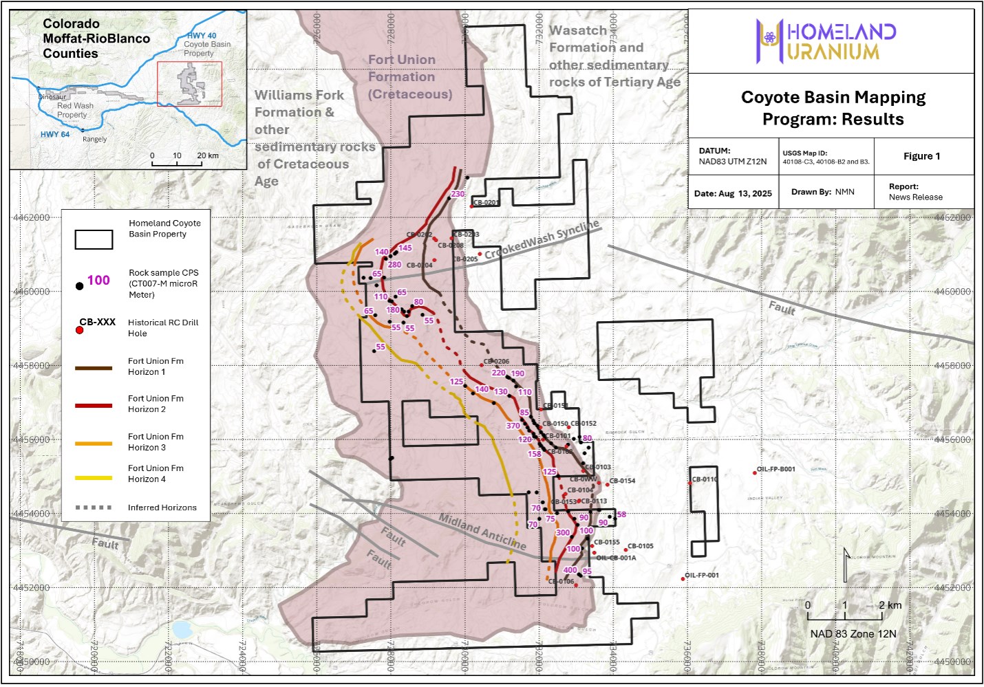
Figure 1: Coyote Basin mapped horizons with rock sample location and associated CPS.
To view an enhanced version of this graphic, please visit:
https://images.newsfilecorp.com/files/10583/262808_27f7aa63e46b9a18_002full.jpg
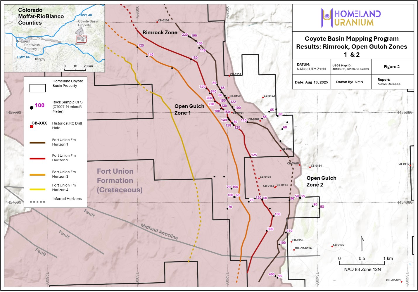
Figure 2: Coyote Basin Open Gulch Zones 1 & 2 mapped horizons with rock sample location and associated CPS.
To view an enhanced version of this graphic, please visit:
https://images.newsfilecorp.com/files/10583/262808_27f7aa63e46b9a18_003full.jpg
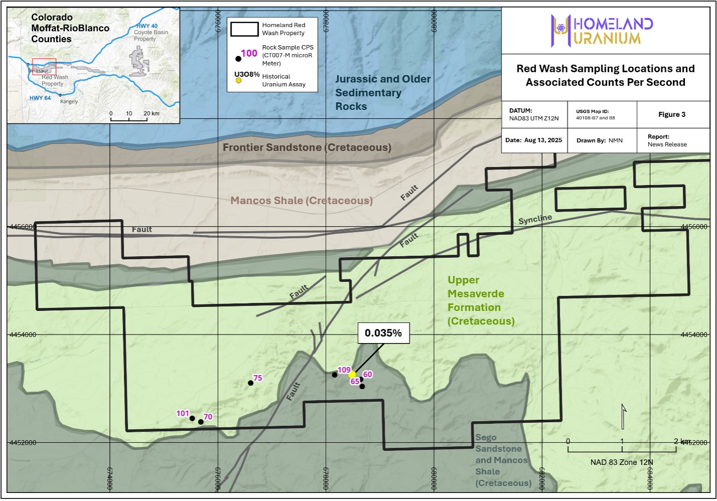
Figure 3: Red Wash property with rock sample location and associated CPS. Historical assay from Nelson-Moore, 19784. Neither the Company or the Qualified Person are able comment on the validity or quality control/quality assurance procedures used by the historical operators regarding the anomalous sample which was reported in the Nelson-Moore, 1978 as they were not disclosed in that report.
To view an enhanced version of this graphic, please visit:
https://images.newsfilecorp.com/files/10583/262808_27f7aa63e46b9a18_004full.jpg
Notes:
1 From W.M.R. internal report, Executive Summary, Coyote Basin Uranium District, Moffat and Rio Blanco Counties, State of Colorado, 1980.
2 Measured using a CT007-M microR Meter.
3 Open-File Report 81-586, https://doi.org/10.3133/ofr81586.
4 Nelson-Moore, J.L., Bishop Collins, D., and Hornbaker, A.L., 1978, Radioactive mineral occurrences of Colorado and bibliography: Colorado Geological Survey Bulletin 40, 1054 p., 12 plates.
![]()
To view the source version of this press release, please visit https://www.newsfilecorp.com/release/262808
© 2025 Newsfile Corp. All rights reserved.