
Element 29 Reports Longest and Highest-Grade Intercepts to Date at Elida with 1,489 m of 0.58% CuEq2
Including 1,152 m of 0.64% CuEq2 (0.49% Cu, 0.04% Mo and 4.65 g/t Ag) with 401.0 m of 0.71% CuEq2 (0.60% Cu, 0.03% Mo, and 7.67 g/t Ag)
Watch the short video of Richard Osmond, CEO, providing highlights -HERE
Vancouver, British Columbia--(Newsfile Corp. - January 26, 2026) - Element 29 Resources Inc. (TSXV: ECU) (OTCQB: EMTRF) (BVL: ECU) ("Element 29" or the "Company") announces results from our ongoing diamond drilling program at its Elida Porphyry Copper ("Cu") - Molybdenum ("Mo") - Silver ("Ag") Deposit ("Elida" or the "Property") in central Perú (Figure 1).
The Company continues to intersect long high-grade intervals of Cu-Mo-Ag mineralization at Elida beginning near surface and extending to vertical depths exceeding 1,400 meters ("m"), highlighting the potential for significant resource expansion beyond the existing pit-constrained Mineral Resource¹. Drill intercepts are reported as down-hole lengths, and the true thicknesses are unknown at this time.
Elida Drilling Highlights
Drill hole ELID037 intersected 0.58% CuEq2 (0.44% Cu, 0.04% Mo, 4.09 g/t Ag) over 1,489.0 m, from bedrock surface to the end of the hole ("EOH") at 1,552.0 m.
Including 1,152.0 m grading 0.64% CuEq2 (0.49% Cu, 0.04% Mo, 4.65 g/t Ag), from a depth of 400.0 m to the EOH.
Several higher-grade Cu-Mo-Ag sub-intervals were intersected in ELID037 including:
401.0 m grading 0.71% CuEq2 (0.60% Cu, 0.03% Mo, 7.67 g/t Ag), starting at a depth of 401.0 m; and
283.8 m grading 0.76% CuEq2 (0.58% Cu, 0.06% Mo, 3.68 g/t Ag), starting at a depth of 1268.2 m.
The Cu grades in ELID037 are increasing at depth with the last 93.8 m grading 0.87% CuEq2 (0.71% Cu, 0.06% Mo, 3.99 g/t Ag), which correlates with the upper part of a large, low resistivity MT geophysical anomaly potentially outlining a large high-grade copper core.
Richard Osmond, President and CEO of Element 29 Resources, states, "The Elida porphyry system continues to impress returning long intercepts of higher-grade copper mineralization extending vertically to a depth of more than 1,400 m, reinforcing our view of Elida as a large, well mineralized porphyry system. We look forward to continuing the current drilling program to advance Elida toward a major copper discovery in a premier mining jurisdiction and delivering significant value for our shareholders in one of the best copper, molybdenum, and silver metals markets in decades. An updated mineral resource is planned upon completion of the 2026 program."
Mr. Osmond continues, "Elida is strategically well located in Perú, situated at low elevation approximately 1,500 metres above sea level and about 75 kilometres from the coast, with access to the national electrical grid, water, a skilled workforce, and multiple deep-water ports. Combined with its low strip ratio and low levels of deleterious elements, all these attributes could position Elida as a future strategic low-cost, low-risk operation."
The 2025 drilling program has met its objectives of advancing exploration at the Elida porphyry Cu-Mo-Ag deposit through step-out drilling to test the potential for resource expansion beyond the current pit shell to depths exceeding 1,000 m, as well as infill drilling within the existing pit shell to increase confidence in the existing Mineral Resource¹ and potentially improve overall Cu-Mo-Ag grades.
Drilling outside the current resource footprint is supported by a 3D resistivity model derived from a recent magnetotellurics ("MT") geophysical survey, which identified several high-priority, untested targets (see news release dated June 26, 2025).
Next Steps
Drilling at Elida continues with two diamond drill rigs still operating. To date, five drill holes have been completed and reported, totaling more than 4,700 m of the planned 7,000 m drilling program. Results from the current drilling will be released as they become available.
The Company plans to complete the remaining 2,300 m of drilling during Q1 2026 under the existing Ficha Técnica Ambiental ("FTA") environmental certification, authorizing up to 20 drilling platforms. Results from the current drilling program are expected to support future drilling, with an additional 5,000 m planned for the first half of 2026.
The Company will continue to follow up on the long, higher-grade Cu-Mo-Ag intercepts from ELID037, ELID033, ELID035, and ELID025, which were drilled along the northern side of the deposit, to evaluate opportunities for resource expansion and further investigate the presence of a deeper high-grade copper core. Drilling will also continue along the southern side of the deposit to assess the potential to increase resources without materially increasing the overall strip ratio. The successful test of the large, low-resistivity MT geophysical anomaly in hole ELID037 has materially increased the interpreted mineralized footprint of the Elida porphyry system, shifting exploration focus on the further evaluation of this exploration target beyond the previously constraining pit shell.
The Company is in the process of applying for a new Programa de Inicio de Actividades ("PIA") drill permit under an upgraded Declaración de Impacto Ambiental ("DIA") environmental certificate, which would authorize up to 40 drilling platform for an additional 5-year term. Approval of the upgraded PIA would represent an important milestone, allowing the Company to significantly expand the permitted drilling footprint, continue exploration beyond the existing mineral resources, and evaluate the broader hydrothermal alteration footprint of the Elida porphyry Cu-Mo-Ag system.
Preliminary metallurgical test work is also planned for Q2 2026 to better understand overall Cu-Mo-Ag concentrate recoveries and potential presence of deleterious elements across key ore types within the Elida deposit.
ELID037 (Figure 2)
ELID037 was drilled to a depth of 1,552.0 m at a dip of -75o towards an azimuth of 270o, corresponding to a vertical depth of approximately 1,479 m, making it the deepest hole drilled at Elida to date. The hole was designed to follow up higher-grade Cu-Mo-Ag mineralization previously intersected at the bottom of ELID033 (refer to news release dated January 22, 2025) and to test a large, low-resistivity MT geophysical anomaly at depth interpreted to represent a deeper, high-grade copper core, a mineralization event commonly associated with economic porphyry copper systems.
The hole intersected approximately 63 m of overburden, followed by 1,489 m grading 0.58% CuEq2 (0.44% Cu, 0.04% Mo, and 4.09 g/t Ag), and was terminated at a depth of 1,552.0 m due to operational constraints.
The entire mineralized interval is strongly potassic altered and comprised predominately of thick sequences of skarn and calcsilicate hornfels, with minor interbedded biotitic hornfels. Local limestone units are partially to completely replaced by semi-massive to massive pyrrhotite-chalcopyrite, interpreted as carbonate replacement deposit ("CRD")-style mineralization.
The interval is crosscut by multiple generations of porphyry-related A- and B-type vein forming stockworks, which are subsequently cut by C-type veins and patches associated with retrograde chlorite-epidote-amphibole alteration.
ELID037 also intersected 1,152 m grading 0.64% CuEq2 (0.49% Cu, 0.04% Mo, 4.65 g/t Ag), starting at a depth of 400 m near the edge of the current pit shell and continuing to EOH at 1,552.0 m, extending the Cu-Mo-Ag mineralization well beyond the existing pit shell.
This interval includes several higher-grade sub-intervals, notably 401.0 m grading 0.71% CuEq2 (0.60% Cu, 0.03% Mo, and 7,67 g/t Ag) starting at 400 m depth, and 283.8 m grading 0.76% CuEq2 (0.58% Cu, 0.06% Mo and 3.68 g/t Ag) from 1,268.2 m to the EOH.
The hole terminated in 93 m grading 0.87% CuEq2 (0.71% Cu, 0.06% Mo, and 3.99 g/t Ag) at 1,552.0 m depth due operational constraints. This deeper, higher-grade Cu-Mo-Ag mineralization remains open at depth and correlates well with the upper portion of the large, low-resistivity MT geophysical anomaly and is interpreted to represent the western edge of a high-grade copper core (Figure 3). Core samples have been sent for petrographic analysis to determine Cu-sulphide mineralogy and the potential presence of bornite in the lower part of this hole with results still pending.
ELID036 (Figure 4)
ELID036 was drilled to a depth of 831.4 m at a dip of -55o towards a 180o azimuth. The hole was designed to (1) infill within the current pit shell to potentially improve overall Cu-Mo-Ag grades, (2) extend mineralization south of the pit shell without materially increasing the strip ratio, and (3) test a large, low-resistivity MT geophysical anomaly located south of the existing pit shell.
Starting at a depth of 122.5 m, the hole intersected 92.7 m grading 0.47% CuEq2 (0.36% Cu, 0.03% Mo and 3.11 g/t Ag), associated with biotitic hornfels interbedded with lesser calcsilicate hornfels. A second intercept of 159.1 m of 0.33% CuEq2 (0.24% Cu, 0.02% Mo and 3.05 g/t Ag) was encountered starting at a depth of 380.9 m, hosted by calcsilicate hornfels interbedded with biotitic hornfels and minor skarn lenses.
In both intercepts, the Cu-Mo-Ag mineralization is associated with porphyry-style A- and B-type vein stockworks, as well as C-type veins related to retrograde chlorite-epidote alteration. These results highlight the potential to increase the overall grades within the pit shell and expand mineral resources to the south. The hole was terminated at a depth of 831.4 m without fully testing the southern low-resistivity MT geophysical anomaly due to a decrease in chalcopyrite mineralization at depth.
ELID038 (Figure 5)
ELID038 was drilled to a depth of 845.1 m at a dip of -70o towards an azimuth of 90o. The hole was designed to test the Elida porphyry system on the eastern side of the current pit shell. The drill collar is positioned immediately west of outcropping, strongly altered volcanoclastic rocks cut by phyllic-altered quartz monzonite porphyry ("QMP") stocks and dykes hosting A-, B-, and D-type veins (intermineral porphyries) that are leached and locally contain visible copper oxide mineralization. The hole was also designed to test several strongly potassic-altered QMP dykes and fingers previously intersected in hole ELID005. These intrusions are interpreted as potassic-altered early porphyries characterized by pervasive secondary biotite replacement, EDM-type veins, and disseminated chalcopyrite.
The hole intersected 667.0 m grading 0.38% CuEq2 (0.28% Cu, 0.03% Mo, and 2.26 g/t Ag) from 48.0 m to 715.0 m depth.
In the upper part of the hole, a sub-interval of 83.0 m grading 0.55% CuEq2 (0.43% Cu, 0.04% Mo and 2.97 g/t Ag), starting at 61.7 m depth, is associated with a phreatic breccia containing heterolithic fragments including mineralized biotitic hornfels, early-intermineral QMPs, and minor skarn, supported in a fragmental rock flour matrix. The mineralization occurs both within breccia fragments and within the matrix as disseminations, stringers, and locally as pockets of semi-massive to massive sulphide replacement.
A second sub-interval of 116.4 m grading 0.49% CuEq2 (0.29% Cu, 0.05% Mo and 1.92 g/t Ag) starting at 447.9 m depth, is associated with C-type veins developed along the structural foliation, as well as open-space-filling veins and local breccias hosted within interbedded biotitic hornfels and fine-grained biotitic sandstones. The hole was terminated at a depth of 845.1 m due to a visible decrease in chalcopyrite mineralization at depth.
ELID039 (Figure 6)
ELID039 was drilled to a depth of 695.1 m at a dip of -50o towards a 180o azimuth. Similar to ELID036, this hole was designed to (1) infill within the current pit-shell to potentially improve the overall Cu-Mo-Ag grades, (2) extend the mineralization outside the pit shell to the south without materially changing the strip ratio, and (3) test a large, low resistivity MT geophysical anomaly observed to the south of the existing pit shell.
The hole intersected 601.7 m grading 0.40% CuEq2 (0.30% Cu, 0.03% Mo, and 4.10 g/t Ag), starting at 13.3 m depth, associated with a sequence of calcsilicate hornfels interbedded with biotitic hornfels and locally cut by phyllic-altered QMP dykes and phreatic breccias.
Within the pit shell, the hole intersected two sub-intervals, including 104.6 m grading 0.57% CuEq2 (0.50% Cu, 0.03% Mo, and 4.66 g/t Ag), starting at depth of 13.3 m and 89.5 m grading 0.42% CuEq2 (0.31% Cu, 0.03% Mo, and 3.31 g/t Ag),starting at a depth 202.5 m. Both mineralized intervals are associated with A- and B-type vein stockworks with later C-type veins developed as stringers along the structural foliation, and as patches within interbedded biotitic hornfels and calcsilicate hornfels. These results highlight the potential to increase the overall grades within the pit shell.
Outside the pit shell, the hole intersected a third sub-interval of 169.5 m grading 0.45% CuEq2 (0.28% Cu, 0.04% Mo, and 6.31 g/t Ag), starting at 445.5 m depth, associated with a thick sequence of calcsilicate hornfels locally cut by phreatic breccias. Mineralization in this interval is also associated with C-type veins developed along the structural foliation, as well as locally developed replacement patches within both the calcsilicate hornfels and phreatic breccias. This sub-interval coincides closely with a low-resistivity MT geophysical anomaly and highlights the potential to further expand mineral resources to the south.
The hole was lost at a depth of 695.1 m before testing the deeper low-resistivity MT geophysical anomaly.
ELID040 (Figure 7)
ELID040 was drilled to a depth of 531.9 m at a dip of -45o towards an azimuth of 175o. The hole was drilled south of holes ELID036 and ELID039 and was designed to (1) infill within the current pit shell to potentially improve overall Cu-Mo-Ag grades, (2) extend mineralization south of the pit shell without materially increasing the strip ratio, and (3) test the margin of the large, low-resistivity MT geophysical anomaly observed south of the current pit shell.
Starting at a depth of 39.6 m, the hole intersected 115.0 m grading 0.42% CuEq2 (0.37% Cu, 0.02% Mo, and 3.53 g/t Ag), associated with a phreatic breccia composed of heterolithic fragments in a rock flour matrix, with minor intervals of intrusive breccia and biotitic hornfels. This interval is followed by calcsilicate hornfels interbedded with skarn and minor biotitic hornfels. Mineralization within the phreatic breccia occurs both within the fragments and the matrix as disseminations, patches, and locally as massive sulphide replacement. Within the calcsilicate hornfels and skarn, mineralization occurs as C-type veins forming along the structural foliation, disseminations, and locally as replacement patches.
The hole also intersected 55.3 m grading 0.38% CuEq2 (0.29% Cu, 0.02% Mo, and 4.83 g/t Ag), starting at 242.6 m depth associated with a second sequence of foliated calcsilicate hornfels interbedded with biotitic hornfels. Mineralization in this interval is characterized by similar C-type veins developed along the structural foliation, disseminations, and locally as replacement patches.
Analytical Quality Control & Quality Assurance
Elida Resources S.A.C., a wholly owned subsidiary of Element 29 Resources Inc., supervises drilling and carries out sampling of HQ and NQ core. Logging and sampling are completed at a secured Company facility situated near the Elida project site. Sample intervals are nominally 2 m long. Drill core is cut in half using a rotary diamond blade saw and samples are sealed on site before transportation to the ALS Peru S.A.C. independent laboratory in Lima by an independent transportation company. Samples are analyzed for 35 elements using an Aqua Regia digestion and ICP-AES analysis (ME-ICP41). Samples reporting over limits are analyzed by Aqua Regia digestion with ICP-AES finish (ME-OG46). ALS meets all requirements of International Standards ISO/IEC 17025:2005 and ISO 9001:2015 for analytical procedures.
Element 29 employs an independent, internal quality assurance/quality control program that includes insertion of duplicate, blank, and certified reference samples at the field site. The Company is not aware of any drilling, sampling, recovery, or other factors that could materially affect the accuracy or reliability of the data reported.
Qualified Person
The scientific and technical content of this news release has been reviewed and approved by Richard Osmond (P.Geo.), Element 29's President and CEO, who is the "Qualified Person" as defined by National Instrument 43-101 Standards for Disclosure for Mineral Projects.
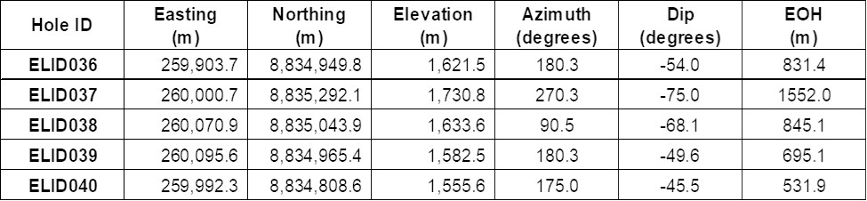
Table 1:Diamond drill hole collar locations and orientations (WGS84/Zone 18S).
To view an enhanced version of this graphic, please visit:
https://images.newsfilecorp.com/files/7414/281526_89884a4ce423d867_001full.jpg
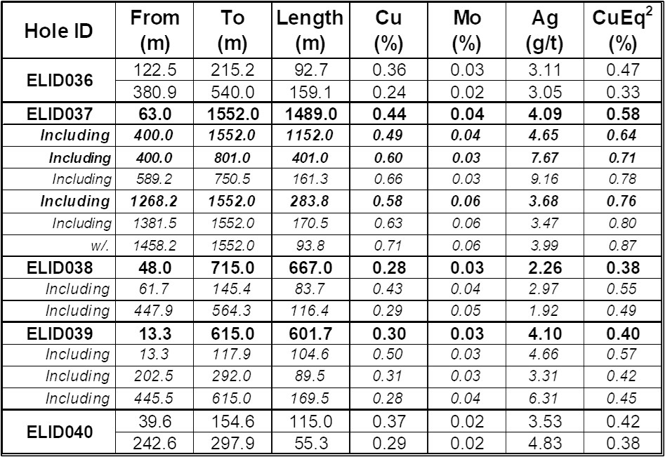
Table 2:Length-weighed assay intervals for holes ELID036, ELID037, ELID038, ELID039, and ELID040.
To view an enhanced version of this graphic, please visit:
https://images.newsfilecorp.com/files/7414/281526_89884a4ce423d867_002full.jpg
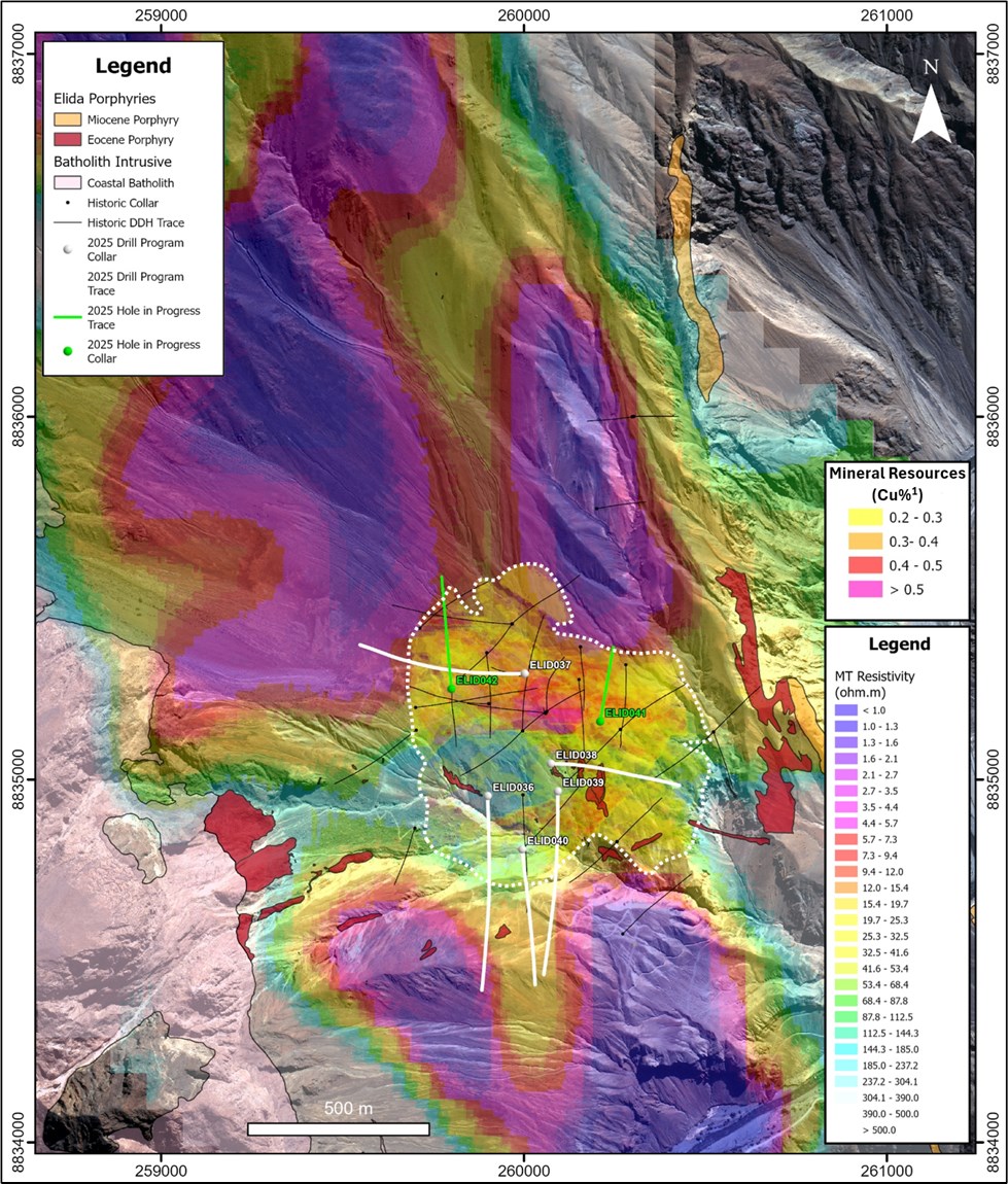
Figure 1: Plan map showing the location of the historical, ongoing and completed drill holes from the 2025 diamond drilling program at Elida. The figure also showing the Mineral Resource Estimate¹ and the -400 m depth slice of the MT 3D resistivity model.
To view an enhanced version of this graphic, please visit:
https://images.newsfilecorp.com/files/7414/281526_89884a4ce423d867_003full.jpg
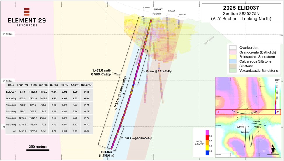
Figure 2: An east-west oriented geological cross section along northing 8,835,325N containing drill hole ELID037. The section shows the length-weighted assay intervals of CuEq2 (%) geochemistry for ELID037 as well as for the historical drill holes. The section also shows a 2D vertical slice along the cross section through the existing pit-constrained Mineral Resource1.
To view an enhanced version of this graphic, please visit:
https://images.newsfilecorp.com/files/7414/281526_89884a4ce423d867_004full.jpg
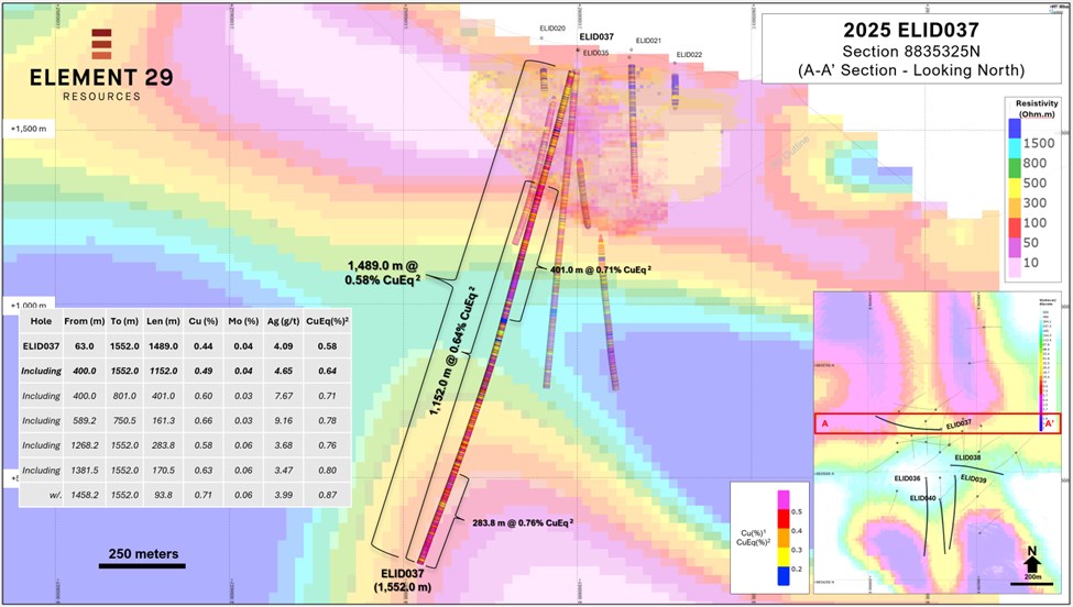
Figure 3:An east-west oriented 2D cross section through the 3D MT resistivity model along northing 8,835,325N also containing drill hole ELID037. The section shows the length-weighted assay intervals of CuEq2 (%) geochemistry for ELID037 as well as for the historical drill holes. The section also shows a 2D vertical slice along the cross section through the existing pit-constrained Mineral Resource1.
To view an enhanced version of this graphic, please visit:
https://images.newsfilecorp.com/files/7414/281526_89884a4ce423d867_005full.jpg
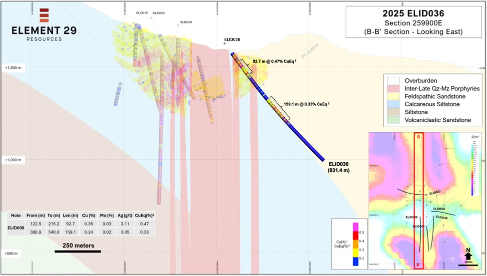
Figure 4: A north-south oriented geological cross section along easting 259,900E containing drill hole ELID036. The section shows the length-weighted assay intervals of CuEq2 (%) geochemistry for ELID036 as well as for the historical drill holes. The section also shows a 2D vertical slice along the cross section through the existing pit-constrained Mineral Resource1.
To view an enhanced version of this graphic, please visit:
https://images.newsfilecorp.com/files/7414/281526_89884a4ce423d867_006full.jpg
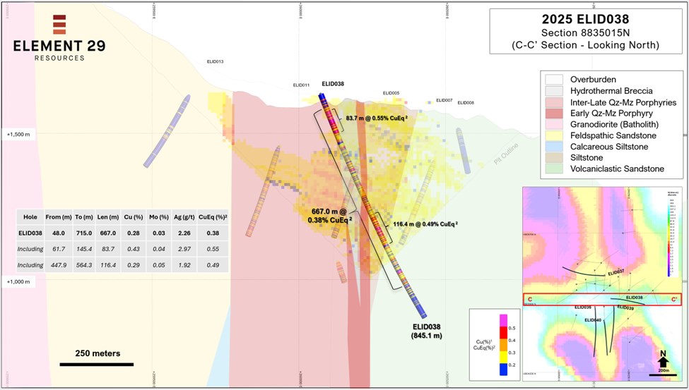
Figure 5: An east-west oriented geological cross section along northing 8,835,015N containing drill hole ELID038. The section shows the length-weighted assay intervals of CuEq2 (%) geochemistry for ELID038 as well as for the historical drill holes. The section also shows a 2D vertical slice along the cross section through the existing pit-constrained Mineral Resource1.
To view an enhanced version of this graphic, please visit:
https://images.newsfilecorp.com/files/7414/281526_89884a4ce423d867_007full.jpg
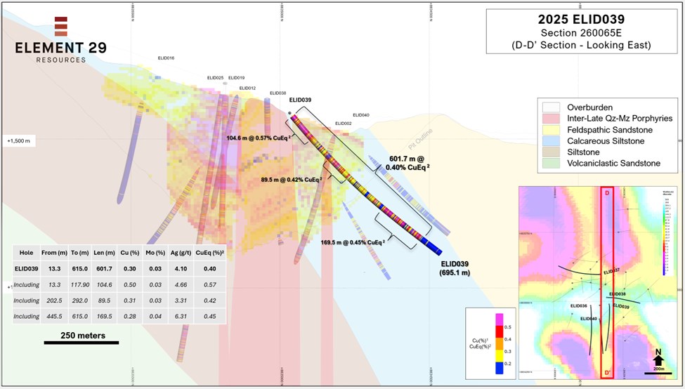
Figure 6: A north-south oriented geological cross section along easting 260,065E containing drill hole ELID039. The section shows the length-weighted assay intervals of CuEq2 (%) geochemistry for ELID039 as well as for the historical drill holes. The section also shows a 2D vertical slice along the cross section through the existing pit-constrained Mineral Resource1.
To view an enhanced version of this graphic, please visit:
https://images.newsfilecorp.com/files/7414/281526_89884a4ce423d867_008full.jpg
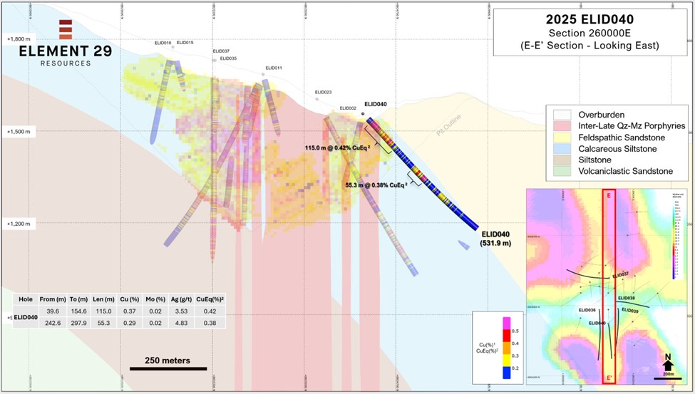
Figure 7: A north-south oriented geological cross section along easting 260,000E containing drill hole ELID040. The section shows the length-weighted assay intervals of CuEq2 (%) geochemistry for ELID040 as well as for the historical drill holes. The section also shows a 2D vertical slice along the cross section through the existing pit-constrained Mineral Resource1.
To view an enhanced version of this graphic, please visit:
https://images.newsfilecorp.com/files/7414/281526_89884a4ce423d867_009full.jpg
About Elida Porphyry Cu-Mo-Ag Deposit
The Elida porphyry Cu-Mo-Ag deposit occurs along the east side of a large block of 32 contiguous concessions totaling 22,800 hectares ("ha") that are 100% owned by Element 29 Resources Inc. The project is in west-central Perú and is road accessible from the capital city, Lima, along the Pan American Highway, 170 kilometres ("km") northwest to the coastal city of Barranca, then inland 75 km along a paved road.
Elida is well located for potential mine development and will benefit from nearby infrastructure and a skilled workforce. The project is situated at a moderate elevation between 1,500 m and 2,000 m with access to transportation routes to coastal shipping ports and power infrastructure, including a 45 mega-watt hydroelectric generation facility situated just 15 km from the Property.
The Elida porphyry complex is a Cu-Mo-Ag mineralized multiphase porphyry system with a 2.5 x 2.5 km hydrothermal alteration footprint at surface, associated with Eocene-aged quartz monzonite stocks, emplaced into the Cretaceous volcano-sedimentary sequence and a granodiorite member of the Peruvian Coastal Batholith. Elida is one of the first Eocene-age mineralized porphyry systems discovered in Perú.
Previous drilling by Element 29 intersected multiple, long intervals of porphyry Cu-Mo-Ag mineralization which has been traced to a depth of greater than 1000 m where it remains open. Most of the Cu-Mo mineralization is carried in A- and B-type vein stockworks that were formed during the waning stages of potassic alteration, with a significant secondary amount of Cu mineralization carried in C-type veins associated with retrograde chlorite-epidote alteration.
The Company has completed 40 drill holes for a total of 23,223.55 metres ("m") of diamond drilling at Elida. Based on just 14,361.4 m of drilling, Element 29 completed an independent pit-constrained Inferred Mineral Resource Estimate in late 2022, which outlined 321.7 million tonnes of 0.32% Cu, 0.029% Mo and 2.61 g/t Ag at a 0.2% Cu cut-off grade and a 0.74:1 strip ratio.
Information on the Mineral Resource Estimate is in the technical report, available on the Company's website and on SEDAR+, titled "NI 43-101 Technical Report, Mineral Resource Estimation of the Elida Porphyry Copper Project in Perú" with an effective date of September 20, 2022 and prepared in accordance with Form 43-101F1 by Marc Jutras, PEng MASc, Principal, Mineral Resources, Ginto Consulting Inc., a Qualified Person as defined in National Instrument 43-101 Standards of Disclosure for Mineral Projects, who is independent of Element 29 Resources Inc.
About Element 29 Resources Inc.
Element 29 is an emerging junior resource company with a highly experienced management team and board focused on exploring and potentially developing copper deposits in Perú, one of the lowest-cost, lowest-risk mining jurisdictions globally.
The Company's principal objective is to explore and potentially develop its Elida Porphyry Copper Deposit in west-central Perú which has an initial inferred Mineral Resource Estimate2 of 321.7 million tonnes grading 0.32% Cu, 0.03% Mo and 2.61 g/t Ag at a 0.2% Cu cutoff grade and a low 0.74:1 modeled strip ratio.
Alongside Elida, the Company has three (3) early stage, highly prospective porphyry Cu projects in Perú for more than 25,000 ha of titled concession. These include the Flor de Cobre porphyry Cu-Mo prospect situated in the Southern Perú Copper Belt, just 26 km from the Cerro Verde copper mine (Freeport-Buenaventura) as well as the Paka and Pahuay porphyry Cu skarn prospects related to potential tertiary-aged, mineralized porphyry complexes intruding along the eastern margin of the Peruvian Coastal Batholith.
All projects are well located for future mine development and will benefit from nearby infrastructure including roads, powerlines, ports, water, and a skilled workforce.
More information is available at www.e29copper.com.
Neither the TSX Venture Exchange (the "TSX-V") nor its Regulation Service Provider (as that term is defined in the policies of the TSX-V)accepts responsibility for the adequacy or accuracy of this press release.
Notes:
The Mineral Resource Estimate information is available in "NI 43-101 Technical Report, Mineral Resource Estimation of the Elida Porphyry Copper Project in Perú" dated September 20, 2022, and prepared in accordance with Form 43-101F1 by Marc Jutras, P.Eng., M.A.Sc., Ginto Consulting Inc.
The CuEq grades are calculated using CuEq = Cu% x 0.85 + [Mo% x 4.2578] + [Ag g/t x 0.0074] utilizing metal recoveries of Cu = 85%, Mo = 65%, and Ag = 65% and metal prices of Cu = US$4.56/lb, Mo = US$29.87/lb and Ag = US$35.50/oz based on a 2-year average of daily spot prices (from January 16, 2024, to January 15, 2026). The spot price of Mo is derived from Molybdenum Bar, 99.9% minimum purity, China converted to US$/lbs.
This news release contains information about adjacent properties on which Element 29 has no right to explore or mine. Readers are cautioned that mineral deposits on adjacent properties are not indicative of mineral deposits on the Company's properties.
Cautionary Note Regarding Forward-Looking Statements
This press release contains certain forward-looking information and forward-looking statements within the meaning of applicable Canadian securities legislation (collectively, "Forward-looking Statements"). Any statements that are contained in this press release that are not statements of historical fact may be deemed to be Forward-looking Statements. Forward-looking Statements are frequently, but not always, identified by words such as "may", "will", "intends", "proposed", "believes", "continues", "plans", "expects" or similar expressions (or the negative and grammatical variations of any of these terms). Forward-looking Statements in this press release include, but are not limited to, statements with respect to the Company's resource properties and future capital requirements; and the Company's plans, focus and objectives.
Forward-looking Statements involve various risks and uncertainties and are based on certain factors and assumptions. Although Element 29's management considers these beliefs and assumptions reasonable based on currently available information, there can be no assurance that such statements will prove to be accurate, and actual results and future events could differ materially from those anticipated in such statements. Forward-looking Statements necessarily involve known and unknown risks, and important factors, among others, that could cause actual results to differ materially from the Company's expectations include: uncertainties related to the Company's ability to access investors for the Financing; the timeliness and success of regulatory approvals; fluctuations in copper and other commodity prices; uncertainties inherent in the exploration of mineral properties; risks associated with general economic conditions; changes in legislation, income tax and regulatory matters; currency and interest rate fluctuations; inability to access sufficient capital from internal and external sources; and other risk factors set forth in the Company's prospectus under the heading "Risk Factors".
Readers are further cautioned not to place undue reliance on Forward-looking Statements as there can be no assurances that the plans, intentions or expectations upon which they are placed will occur. The Company undertakes no obligation to update or revise any Forward-looking Statements, whether as a result of new information, future events or otherwise, except as may be required by law. New factors emerge from time to time, and it is not possible for Element 29 to predict all of them or assess the impact of each such factor or the extent to which any factor, or combination of factors, may cause results to differ materially from those contained in any Forward-looking Statement. Any Forward-looking Statements contained in this press release are expressly qualified in their entirety by this cautionary statement.1This news release contains information about adjacent properties on which Element 29 has no right to explore or mine. Readers are cautioned that mineral deposits on adjacent properties are not indicative of mineral deposits on the Company's properties.
![]()
To view the source version of this press release, please visit https://www.newsfilecorp.com/release/281526
Source: Element 29 Resources Inc.
© 2026 Newsfile Corp. All rights reserved.