

Kirkland Lake Discoveries Drills Broad Zones of Intense "Brick-Red" Syenite Alteration at Wolverine Bend, Hits Semi-Massive Sulphides and Fluorite at Winnie Lake; Drill Program Surpasses 10,000 Metres
Highlights:
District-Scale Potential Confirmed:Over 10,000 m of the 25,000-m program are complete, with visual results consistently confirming a massive, fluid-rich mineralizing system.
Wolverine Bend Footprint Growing:Step-out drilling has hit continuous, tens-of-metres intervals of intense "brick-red" alteration, the hallmark signature of major syenite-hosted gold deposits in the Kirkland Lake camp.
Winnie Lake System Expanding:Discovery of semi-massive sulphides and high-temperature minerals like fluorite and molybdenite indicates a highly fertile, expanding polymetallic system.
New Regional Targets Validated:First-pass drilling at the Sharp Target has successfully identified a new, 65-metre-thick sulphide-bearing horizon, proving the property's potential for grassroots discoveries.
Fully Funded & Advancing:Two rigs are operating 24/7 to complete the remaining 15,000 m of the winter program.
Toronto, Ontario--(Newsfile Corp. - February 23, 2026) - Kirkland Lake Discoveries Corp. (TSXV: KLDC) (OTCID: KLKLF) ("KLDC" or the "Company") is pleased to provide a comprehensive geological and visual update on its ongoing, fully funded 25,000-m diamond drilling program at the KL West Property in the Kirkland Lake region of Ontario.
With over 10,000 m now completed, the Company is reporting highly encouraging visual and observational results from the core logging facility. Recent drilling has consistently intersected hallmark geological indicators of a large-scale, intrusion-related gold and polymetallic system.
While analytical assays are pending for all holes drilled since the late January update, core logging confirms that the mineralizing systems across the 17-km Winnie Lake Stock (WLS) corridor are structurally robust, extremely fluid-rich, and rapidly expanding in scale (see Figure 1).
"The visual observations coming out of the KL West program is a significant milestone for us," stated Stefan Sklepowicz, Chief Executive Officer. "When you see intense 'brick-red' hematite alteration at Wolverine Bend alongside coarse copper and molybdenite at Winnie Lake, you aren't just looking at rocks, you're looking at the absolute textbook signature of a massive hydrothermal system."
"These are the exact geological markers that historically guided explorers to the legendary deposits of the Abitibi. While we are eagerly awaiting the laboratory assays to confirm the grades, the sheer scale of the alteration we are logging gives us tremendous confidence that we are onto a district-scale opportunity. We have multiple mineralizing events overlapping across this corridor, and the system appears to be getting stronger as we go deeper."
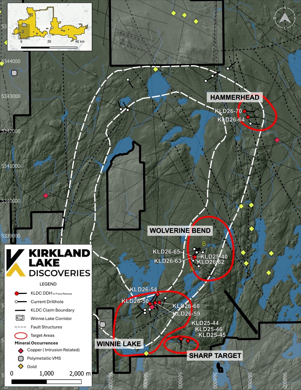
Figure 1 - KL West Project Area - Drilling Targets and Collar Locations
To view an enhanced version of this graphic, please visit:
https://images.newsfilecorp.com/files/5701/284832_c48f2957b44de84a_001full.jpg
Wolverine Bend: Expanding the Alteration Footprints
Following the successful January release of gold assays from the Wolverine Bend target, which confirmed gold vectoring within altered syenite and returned 8.3 m at 0.86 g/t Au, including 5.5 m at 1.21 g/t Au in hole KLD25-40, the Company initiated an aggressive step-out and undercut drilling campaign to test the depth and strike extensions of the mineralized system.
Visual logging from the new drill holes confirms that the hydrothermal alteration footprint is both laterally extensive and vertically persistent. The system is characterized by intense, primary-texture-destructive potassic alteration accompanied by pervasive hematite, producing the distinctive "brick-red" altered syenite that has become diagnostic of the Wolverine Bend target. Alteration intensity appears to increase at depth and along projected structural corridors (see Figure 2).
Step-Out and Undercut Drilling Highlights (Assays Pending)
KLD26-62: Collared approximately 40 m south of KLD25-40, this hole successfully intersected extensive intervals of strong potassic-hematite alteration from approximately 100 m to 240 m downhole, including a structurally focused zone between 150 m and 185 m featuring significant quartz veining proximal to a fault zone (see Figure 3).
KLD26-63 and KLD26-65: Drilled from the same pad at azimuths of 50° and 10° respectively, these undercut holes tested the system down-dip.
KLD26-63 intersected a continuous 39-m interval of strong alteration beginning at 5.6 m downhole, including a 13-m interval starting at 41.56 m characterized by intense potassic alteration with quartz-carbonate stringers. Elevated alteration persists to approximately 146 m (see Figure 4).
KLD26-65 intersected comparable zones of intense alteration over contiguous intervals from 6 m to 67 m downhole, with elevated alteration extending to approximately 93 m (see Figure 5).
The volume and intensity of the potassic-hematite alteration overprinted by brittle quartz brecciation at Wolverine Bend closely mirrors the core characteristics of the Kirkland Lake camp's most prolific syenite-hosted gold deposits.
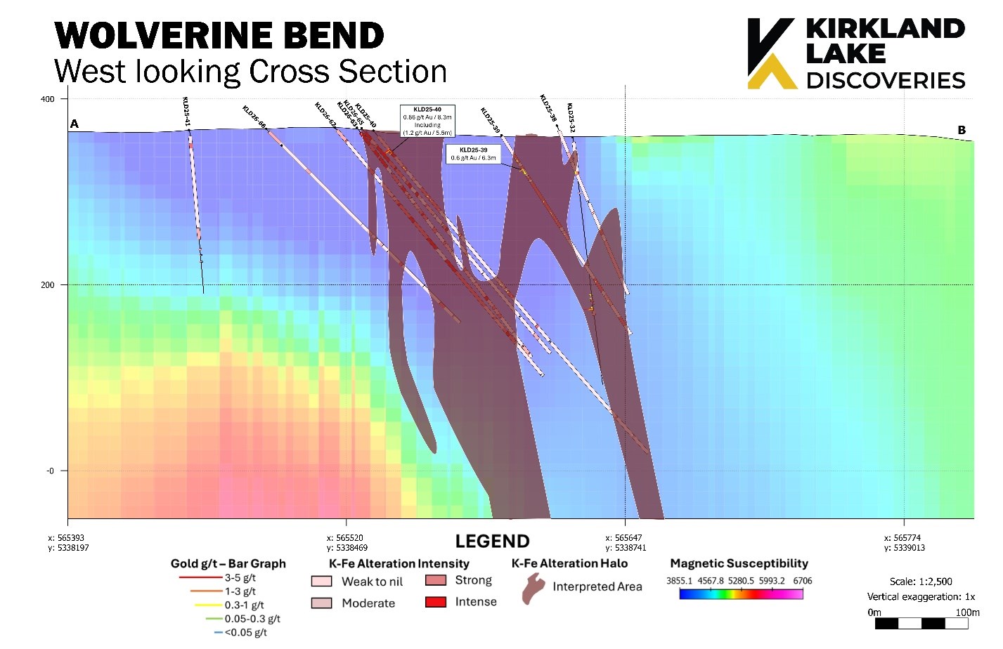
Figure 2 - West looking cross section of Wolverine Bend Area. Interpretation of Potassium and Hematite alteration envelope described as strong or intense.
To view an enhanced version of this graphic, please visit:
https://images.newsfilecorp.com/files/5701/284832_c48f2957b44de84a_002full.jpg
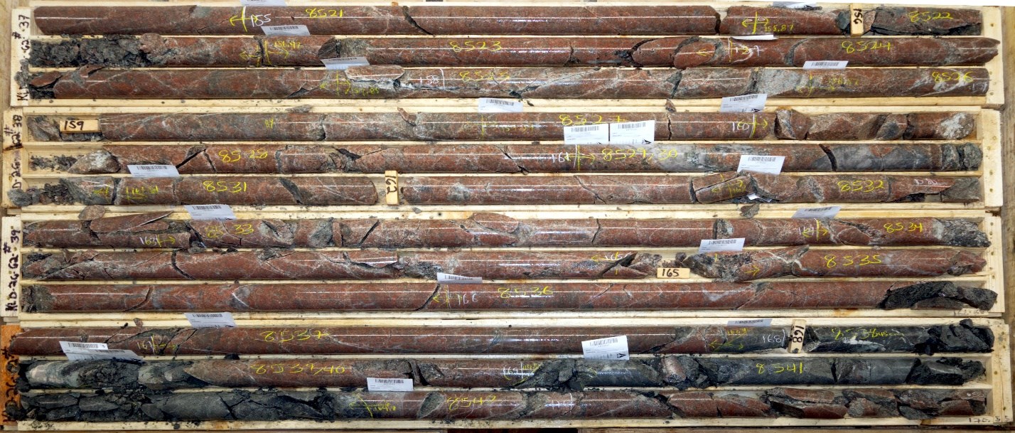
Figure 3 - KLD26-62 Boxes 37-40 (154.70-170.55m)
To view an enhanced version of this graphic, please visit:
https://images.newsfilecorp.com/files/5701/284832_c48f2957b44de84a_003full.jpg
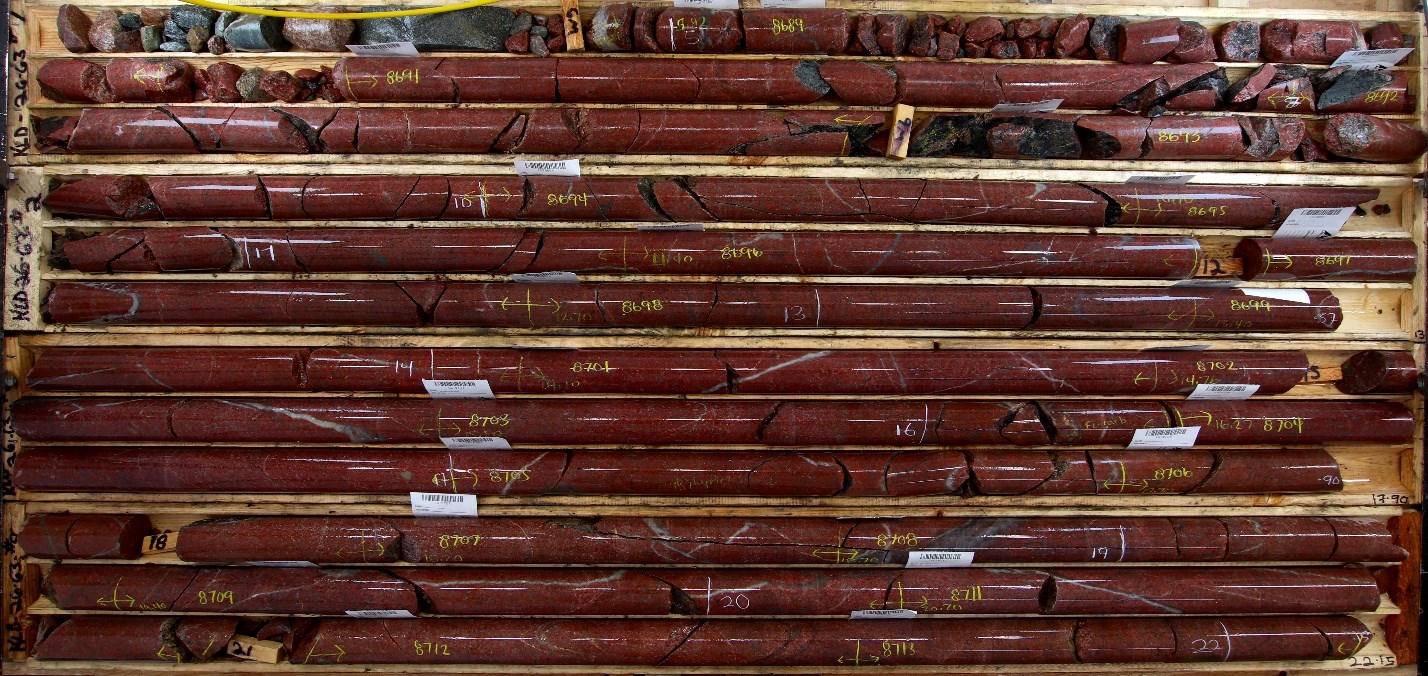
Figure 4 - KLD26-63 Boxes 1-4 (5.6-22.15m)
To view an enhanced version of this graphic, please visit:
https://images.newsfilecorp.com/files/5701/284832_c48f2957b44de84a_004full.jpg
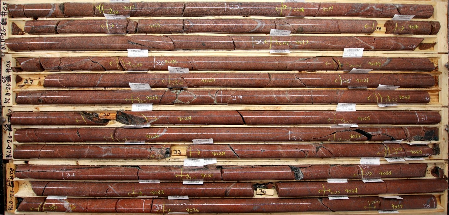
Figure 5- KLD26-65 Box 5-8 (21.25-38.00m)
To view an enhanced version of this graphic, please visit:
https://images.newsfilecorp.com/files/5701/284832_c48f2957b44de84a_005full.jpg
Winnie Lake Area: Expanding Polymetallic and Intrusive-Related Mineralization
Drilling at Winnie Lake continues to demonstrate the presence of both VMS-style volcanic-hosted mineralization and structurally controlled intrusive-related sulphide systems east and north of the historical Winnie Main Deposit.
Winnie Main - East Trend Extension
Step-out drilling along the East Trend confirms continuity of sulphide mineralization beyond the historical workings.
KLD26-59 intersected a 27.7-m interval (83.1m to 110.8 m) and KLD26-60 intersected a 21.5-m interval (102.5m to 124.0m) containing elevated pyrite with localized pyrite and chalcopyrite mineralization associated with epidote-altered mafic volcanics with intercalated syenite and quartz-calcite veining along an east-plunging volcanic horizon (see Figure 6).
The interval supports the extension of the Winnie Main VMS polymetallic system along strike to the east and at depth.
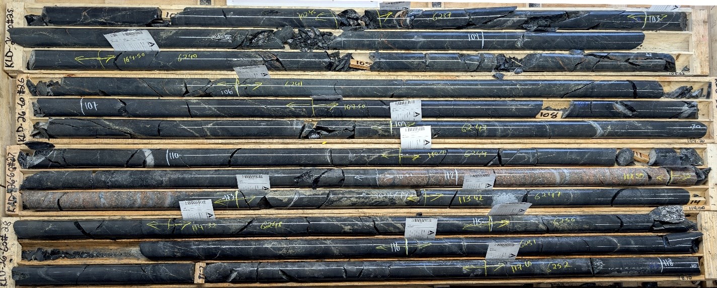
Figure 6 - KLD26-60 Box 25-28 (101.76-118.10m)
To view an enhanced version of this graphic, please visit:
https://images.newsfilecorp.com/files/5701/284832_c48f2957b44de84a_006full.jpg
Peripheral Intrusive and Structural Corridor (East and North of Winnie Main)
Drilling east and north of the historical deposit is outlining a distinct structurally controlled corridor hosted within syenite and gabbro intrusive rocks.
KLD26-50 (Mini Winnie) intersected a 15-m interval (118.6 m to 133.88 m) of semi-massive to stringer pyrite with blebby chalcopyrite within mafic volcanic rocks, indicating robust sulphide development along the structural corridor.
KLD26-54, drilled approximately 350 m north of Winnie Main, targeted a northwest-southeast-oriented magnetic structure. The hole intersected strongly potassic-altered syenite between 352.25 m and 376.08 m downhole containing pyrite, chalcopyrite, and molybdenite mineralization. The alteration intensity and mineral assemblage are consistent with evolved magmatic-hydrothermal fluids focused along this interpreted structural corridor.
Regional Targets: Sharp and Hammerhead
The program has also begun testing regional grassroots targets identified by coincident soil and geophysical anomalies, unlocking new geological environments.
Sharp Target (KLD25-44, -45, -46): First-pass drilling designed to test an MT resistivity low coincident with an EM anomaly and historical Zn-Pb-Ag-bearing graphitic horizon, successfully identified a new geological setting on the property. Drilling intersected thick packages of graphitic mudstones interlayered with pillowed mafic volcanics. The mudstone horizons host broad intervals (up to 65 m true width) of heavily disseminated, blebby, and stringer pyrite, pyrrhotite, sphalerite and galena.
Hammerhead Target (KLD26-64): Testing a resistivity high and soil anomaly, this hole intersected highly altered mafic volcanics featuring a broad 93-m zone (162.0 m to 255.0 m) of moderate epidote alteration. Within this, significant sulphide mineralization occurs as blebs and stringers between 240.35 m and 259.06 m.
Program Overview and Next Steps
Drilling metrics to date include:
Total metres drilled: 10,833 m
Number of completed holes: 32
Drill rigs active: Two
| Totals | Wolverine Bend | Winnie Lake | Nine Mile | Cross Roads | Hammerhead | Sharp Target | |
| Number DDH | 32 | 10 | 11 | 3 | 3 | 2 | 3 |
| Meters Drill | 10,833 | 3,051 | 4,007 | 1,116 | 1,110 | 772 | 777 |
Core logging, geological interpretation, and sampling are ongoing at the Company's facility. Hundreds of samples are currently in the queue at ALS Laboratories. The Company will begin reporting analytical assay results as they are received, validated, and interpreted over the coming weeks.
Ongoing Exploration Strategy
The Company will continue expanding the alteration footprint at Wolverine Bend, where drilling has defined broad potassium-hematite alteration and structurally controlled mineralization consistent with a large hydrothermal system. Upcoming drilling will target strike and depth extensions to further define the scale and continuity of the corridor.
Several recently completed holes remain pending assay results, which will provide additional data to refine ongoing exploration planning.
At Winnie Lake, drilling continues to advance both the extension of the Winnie Main VMS polymetallic horizon and a newly emerging intrusive-hosted structural corridor east and north of the historical deposit. Step-out drilling along the East Trend confirms sulphide continuity beyond historical workings, while deeper drilling into syenite and gabbro units has intersected copper-bearing breccias and strongly potassic-altered intrusive phases associated with molybdenite and chalcopyrite mineralization. Assay results from several recent intercepts across both the VMS and intrusive corridors remain pending, and follow-up holes are planned to further delineate these zones.
Regionally, the Company is advancing a pipeline of high-priority targets generated through integrated geochemistry, MobileMT inversion, magnetic reinterpretation, and structural modeling. Drilling will systematically test:
Major structurally controlled deformation corridors interpreted as long-lived, deep-tapping fluid pathways
Magnetic high margins and associated magnetic destruction halos linked to hydrothermal alteration
Intrusion-related geochemical vectors, including Bi-Te-Mo enrichment and elevated K/Na ratios
Downhole magnetic susceptibility reductions indicative of magnetite-destructive alteration
East-west deformation corridors and subsidiary fault splays prospective for orogenic-style gold mineralization
Conductive volcanic sequences with base-metal pathfinder signatures consistent with VMS systems
With assay results of multiple mineralized intercepts pending and a growing inventory of structurally defined targets, the Company believes the current drill program has the potential to materially advance understanding of the scale and continuity of mineralization across the district.
Note on visual estimates: The Company cautions that visual estimates of mineral abundance (including chalcopyrite, molybdenite, fluorite, and pyrite) should never be considered a proxy or substitute for laboratory analyses where concentrations or grades are the factor of principal economic interest. Visual estimates also potentially provide no information regarding impurities or modifying factors relevant to economic evaluation.
Video Footage
The latest episode of KLDC's Treasure Hunters YouTube series features video of the core and discussions with VP Exploration Ben Cleland and CEO Stefan Sklepowicz.
Cannot view this video? Visit:
https://www.youtube.com/watch?v=YI31Dcdy3XY
Quality Control Statement True widths are estimated at approximately 65-80% of the reported core length intervals. All NQ drill core samples are prepared for analysis at ALS Laboratories in Ontario, Québec, and British Columbia. Drill program design, Quality Assurance/Quality Control ("QA/QC"), and interpretation of results are conducted by qualified persons employing a QA/QC program consistent with National Instrument 43-101 and industry best practices.
Qualified Person The technical information contained in this news release has been reviewed and approved by Benjamin Cleland, P.Geo., Vice-President Exploration, who is a Qualified Person as defined by National Instrument 43-101 - Standards of Disclosure for Mineral Projects.
About Kirkland Lake Discoveries Corp. Kirkland Lake Discoveries Corp. (TSXV: KLDC) has assembled a 400-km² exploration portfolio in the Kirkland Lake region of Ontario's Abitibi Greenstone Belt, one of the most prolific mining districts in the world. The Company's properties span key fault zones, geophysical anomalies, and volcanic-sedimentary contacts within the Blake River Group, a highly prospective assemblage known to host both gold and polymetallic massive-sulphide deposits.
With exploration permits now in place, KLDC is positioned to advance a strong pipeline of drill-ready targets at KL East and KL West, supported by multiple anomalous soil trends, historical mineral showings, and structurally controlled intersections. The team combines strong technical experience with a focus on smart, efficient exploration designed to deliver results.
Neither TSX Venture Exchange nor its Regulation Services Provider (as that term is defined in policies of the TSX Venture Exchange) accepts responsibility for the adequacy or accuracy of this release.
Forward-Looking Statements This news release contains "forward-looking statements" within the meaning of applicable securities legislation. All statements, other than statements of historical fact, are forward-looking statements. Forward-looking statements in this news release relate to, among other things, future drill programs, the results thereof, and the potential for new discoveries. There can be no assurance that such statements will prove to be accurate, and actual results and future events could differ materially from those anticipated in such statements. The Company does not assume any obligation to update forward-looking statements of beliefs, opinions, projections, or other factors, should they change, except as required by applicable securities laws. Mineralization hosted on adjacent and/or nearby properties is not necessarily indicative of mineralization hosted on the Company's property.
![]()
To view the source version of this press release, please visit https://www.newsfilecorp.com/release/284832
Source: Kirkland Lake Discoveries Corp.
© 2026 Newsfile Corp. All rights reserved.