



ReeXploration Reports Downhole Gamma Results Supporting an Extensive Uranium System at Eureka in Namibia
Halifax, Nova Scotia--(Newsfile Corp. - October 6, 2026) - ReeXploration Inc. (TSXV: REE) (FSE: K2I0) ("ReeXploration" or the "Company") reports downhole gamma results that confirm repeated and widespread equivalent uranium oxide (eU₃O₈) responses within leucogranite intrusions and their contacts at the Eureka Project in central Namibia. The Eureka Project combines the uranium and rare earth exploration opportunities. Together with the drill-core geology and previously reported uranium occurrences, the results support a leucogranite-hosted uranium system and warrant targeted follow-up exploration.
The downhole gamma surveys build on the 11-hole, 1,729-metre reconnaissance drilling program ("Phase 1") reported on April 9, 2026, which tested selected leucogranite targets within a previously announced 6.5 by 3.5 kilometre regional radiometric uranium anomaly. In addition to its existing rare earth element resource and further REE exploration potential, Eureka presents two distinct uranium exploration opportunities: 1) uranium associated with leucogranite bedrock and its contacts, and 2) shallow secondary uranium in calcrete and related weathered material. The new results and historical work warrant further investigation of both target types.
Downhole Gamma Highlights from Phase 1 Drilling
- SU26-08 returned 16.7 metres averaging 79.2 ppm eU₃O₈, including 1.2 metres at 218.2 ppm and 1.0 metre at 182.6 ppm, across leucogranite and mica schist.
- SU26-04 returned 4.9 metres averaging 139.7 ppm eU₃O₈, including 4.3 metres at 146.3 ppm, across leucogranite and biotite schist. A separate deeper composite returned 15.2 metres at 66.1 ppm.
- SU26-01 returned 1.5 metres averaging 187.3 ppm eU₃O₈, including 1.0 metre at 242.7 ppm, across a leucogranite–calc-silicate schist contact. The peak reading was 369.2 ppm eU₃O₈.
- A separate shallow calcrete target warrants follow-up, supported by visible uranium (carnotite), near-surface gamma responses and historical exploration documenting secondary uranium in calcrete, gypcrete and weathered bedrock.
"The results give us two clear directions for follow-up: the leucogranites and their contacts at depth, and the shallow calcrete system,"said Brenan Isabelle, CEO. "With nuclear power expansion driving expectations for higher uranium demand and utilities increasingly focused on securing long-term supplies, there is a strong case for exploring new uranium targets in Namibia. At Eureka, the repeated bedrock responses support our geological model, while historical work highlights a separate shallow opportunity. Together, these results provide a clear foundation for advancing both target types across Eureka's expansive uranium exploration footprint. This uranium potential complements Eureka's existing rare earth element resource and further REE exploration potential, strengthening the broader exploration case for the project."
Phase 1 Downhole Gamma Results
Terratec Geophysical Services Namibia completed downhole gamma surveys to measure gamma radioactivity along the accessible portions of the drillholes. The surveys provide a depth profile of equivalent uranium oxide concentrations (eU₃O₈) from a calibrated probe, helping identify intervals of interest and their relationship to the logged geology.
Composites at the 50 ppm threshold occur in the logged portions of all eleven holes. Readings above 100 ppm occur in seven holes.
Blockages limited logging in SU26-02, SU26-09 and SU26-11 to approximately 58, 40 and 22 metres, respectively. Deeper, unlogged sections are not represented in the results. In particular, the deeper radioactive intervals previously reported in SU26-11 lie below the logged section and cannot be assessed using these surveys.
Table 1: Phase 1 gamma composites at a 50 ppm lower cut off.
| Drill hole | From (m) | To (m) | Length (m) | Average eU₃O₈ (ppm) | Peak eU₃O₈ (ppm) | Logged lithology |
| SU26-01 | 1.25 | 1.45 | 0.2 | 51.1 | 51.1 | Calc-silicate |
| SU26-01 | 35.35 | 35.75 | 0.4 | 59.2 | 62.2 | Leucogranite |
| SU26-01 | 43.05 | 43.95 | 0.9 | 74.5 | 89.9 | Leucogranite |
| SU26-01 | 45.25 | 47.05 | 1.8 | 73.1 | 155.7 | Leucogranite; Biotite schist; Calc-silicate schist |
| including | 45.35 | 45.55 | 0.2 | 149.7 | 155.7 | Biotite schist |
| SU26-01 | 50.25 | 50.45 | 0.2 | 65.2 | 72.2 | Pegmatite; Calc-silicate schist |
| SU26-01 | 91.95 | 92.35 | 0.4 | 58.6 | 69.6 | Calc-silicate schist |
| SU26-01 | 96.15 | 96.85 | 0.7 | 64.4 | 73.1 | Leucogranite |
| SU26-01 | 106.85 | 108.15 | 1.3 | 69.8 | 82.6 | Leucogranite |
| SU26-01 | 110.35 | 113.85 | 3.5 | 65.5 | 94.8 | Leucogranite; Calc-silicate schist |
| SU26-01 | 118.55 | 118.65 | 0.1 | 50.6 | 50.6 | Leucogranite |
| SU26-01 | 119.45 | 119.55 | 0.1 | 51.9 | 51.9 | Leucogranite |
| SU26-01 | 120.05 | 120.75 | 0.7 | 51.7 | 57.5 | Calc-silicate schist |
| SU26-01 | 124.25 | 125.95 | 1.7 | 141.1 | 205.6 | Leucogranite; Calc-silicate schist |
| including | 124.35 | 125.85 | 1.5 | 151.2 | 205.6 | Leucogranite; Calc-silicate schist |
| SU26-01 | 138.05 | 139.55 | 1.5 | 187.3 | 369.2 | Leucogranite; Calc-silicate schist |
| including | 138.45 | 139.45 | 1.0 | 242.7 | 369.2 | Leucogranite; Calc-silicate schist |
| SU26-01 | 143.05 | 143.35 | 0.3 | 55.6 | 60.0 | Leucogranite |
| SU26-01 | 144.55 | 147.45 | 2.9 | 104.0 | 151.6 | Leucogranite; Calc-silicate schist |
| including | 145.25 | 146.85 | 1.6 | 129.9 | 151.6 | Leucogranite; Calc-silicate schist |
| SU26-02 | 14.55 | 26.05 | 11.5 | 60.8 | 89.2 | Leucogranite |
| SU26-02 | 50.95 | 51.85 | 0.9 | 65.3 | 74.3 | Leucogranite; Dolerite |
| SU26-02 | 54.75 | 56.65 | 1.9 | 50.5 | 65.0 | Dolerite; Leucogranite |
| SU26-03 | 0.85 | 2.25 | 1.4 | 56.3 | 72.2 | Biotite schist |
| SU26-03 | 49.65 | 49.75 | 0.1 | 53.0 | 53.0 | Leucogranite; Calc-silicate schist |
| SU26-04 | 0.95 | 4.35 | 3.4 | 55.4 | 73.2 | Gypcrete; Leucogranite |
| SU26-04 | 8.95 | 15.15 | 6.2 | 57.7 | 80.7 | Leucogranite |
| SU26-04 | 16.65 | 23.25 | 6.6 | 53.0 | 69.0 | Leucogranite |
| SU26-04 | 24.65 | 24.85 | 0.2 | 54.0 | 54.8 | Leucogranite |
| SU26-04 | 38.45 | 38.85 | 0.4 | 58.6 | 65.6 | Leucogranite |
| SU26-04 | 39.55 | 41.25 | 1.7 | 54.0 | 79.3 | Leucogranite |
| SU26-04 | 46.25 | 47.15 | 0.9 | 73.5 | 83.9 | Leucogranite; Biotite schist |
| SU26-04 | 53.65 | 53.75 | 0.1 | 51.5 | 51.5 | Leucogranite |
| SU26-04 | 55.85 | 57.55 | 1.7 | 51.9 | 60.1 | Leucogranite; Amygdaloidal dyke |
| SU26-04 | 62.25 | 62.95 | 0.7 | 53.7 | 58.2 | Leucogranite; Biotite schist |
| SU26-04 | 66.25 | 66.95 | 0.7 | 115.7 | 152.7 | Dolerite |
| including | 66.35 | 66.85 | 0.5 | 129.8 | 152.7 | Dolerite |
| SU26-04 | 77.15 | 77.25 | 0.1 | 51.9 | 51.9 | Biotite schist |
| SU26-04 | 80.05 | 84.95 | 4.9 | 139.7 | 234.5 | Leucogranite; Biotite schist |
| including | 80.15 | 80.35 | 0.2 | 115.3 | 126.6 | Leucogranite |
| including | 80.55 | 84.85 | 4.3 | 146.3 | 234.5 | Leucogranite; Biotite schist |
| SU26-04 | 102.25 | 102.75 | 0.5 | 71.0 | 80.4 | Calc-silicate schist |
| SU26-04 | 116.15 | 116.75 | 0.6 | 64.0 | 81.9 | Calc-silicate schist |
| SU26-04 | 139.25 | 139.85 | 0.6 | 84.1 | 100.9 | Dolerite |
| including | 139.65 | 139.75 | 0.1 | 100.9 | 100.9 | Dolerite |
| SU26-04 | 142.85 | 143.05 | 0.2 | 54.6 | 57.6 | Biotite schist |
| SU26-04 | 147.85 | 152.35 | 4.5 | 65.3 | 95.0 | Leucogranite |
| SU26-04 | 164.55 | 165.35 | 0.8 | 62.8 | 76.1 | Leucogranite |
| SU26-04 | 166.75 | 167.35 | 0.6 | 68.2 | 89.6 | Calc-silicate schist |
| SU26-04 | 170.75 | 185.95 | 15.2 | 66.1 | 176.5 | Leucogranite; Biotite schist |
| including | 175.55 | 175.65 | 0.1 | 116.8 | 116.8 | Biotite schist |
| including | 176.55 | 176.85 | 0.3 | 135.3 | 150.4 | Leucogranite |
| including | 179.05 | 179.25 | 0.2 | 103.3 | 105.1 | Leucogranite |
| including | 180.85 | 181.65 | 0.8 | 150.3 | 176.5 | Leucogranite |
| SU26-04 | 188.85 | 189.85 | 1.0 | 53.4 | 60.0 | Leucogranite |
| SU26-04 | 192.05 | 192.55 | 0.5 | 68.6 | 88.9 | Calc-silicate schist |
| SU26-04 | 197.45 | 197.75 | 0.3 | 55.0 | 63.3 | Leucogranite |
| SU26-04 | 199.15 | 200.15 | 1.0 | 86.6 | 106.0 | Calc-silicate schist |
| including | 199.55 | 199.75 | 0.2 | 103.8 | 106.0 | Calc-silicate schist |
| SU26-05 | 0.65 | 1.15 | 0.5 | 51.0 | 51.4 | Gypcrete |
| SU26-05 | 15.55 | 16.75 | 1.2 | 53.5 | 60.1 | Leucogranite |
| SU26-05 | 27.45 | 28.05 | 0.6 | 58.4 | 72.2 | Leucogranite |
| SU26-05 | 29.55 | 30.25 | 0.7 | 50.4 | 55.4 | Leucogranite |
| SU26-05 | 35.15 | 36.35 | 1.2 | 107.5 | 188.8 | Leucogranite |
| including | 35.35 | 35.75 | 0.4 | 157.9 | 188.8 | Leucogranite |
| including | 36.05 | 36.15 | 0.1 | 108.4 | 108.4 | Leucogranite |
| SU26-06 | 1.35 | 4.35 | 3.0 | 71.4 | 159.9 | Gypcrete; Leucogranite; Calcrete; Biotite schist |
| including | 1.35 | 1.95 | 0.6 | 143.3 | 159.9 | Gypcrete |
| SU26-06 | 51.75 | 51.85 | 0.1 | 53.1 | 53.1 | Calc-silicate schist; Leucogranite |
| SU26-06 | 52.35 | 52.55 | 0.2 | 55.6 | 55.7 | Leucogranite; Calc-silicate |
| SU26-07 | 1.25 | 1.85 | 0.6 | 55.0 | 61.6 | Calc-silicate schist |
| SU26-07 | 54.25 | 59.95 | 5.7 | 57.0 | 75.1 | Leucogranite |
| SU26-07 | 67.25 | 67.45 | 0.2 | 62.9 | 63.0 | Calc-silicate schist |
| SU26-07 | 102.65 | 103.15 | 0.5 | 66.2 | 75.0 | Dolerite |
| SU26-07 | 106.45 | 108.45 | 2.0 | 57.1 | 73.3 | Leucogranite |
| SU26-07 | 118.45 | 118.85 | 0.4 | 56.8 | 63.2 | Leucogranite; Calc-silicate schist |
| SU26-08 | 1.65 | 2.45 | 0.8 | 55.7 | 60.6 | Calc-silicate schist |
| SU26-08 | 119.05 | 120.45 | 1.4 | 51.2 | 62.5 | Biotite schist; Leucogranite |
| SU26-08 | 123.35 | 140.05 | 16.7 | 79.2 | 333.9 | Leucogranite; Mica schist |
| including | 135.05 | 136.25 | 1.2 | 218.2 | 333.9 | Mica schist |
| including | 137.25 | 138.25 | 1.0 | 182.6 | 266.0 | Leucogranite |
| SU26-09 | 1.05 | 7.55 | 6.5 | 91.0 | 163.8 | Calcrete; Calc-silicate schist |
| including | 1.05 | 1.45 | 0.4 | 112.7 | 120.2 | Calcrete |
| including | 1.95 | 2.55 | 0.6 | 123.5 | 134.0 | Calc-silicate schist |
| including | 3.05 | 4.25 | 1.2 | 121.3 | 159.3 | Calc-silicate schist |
| including | 4.35 | 5.05 | 0.7 | 132.4 | 163.8 | Calc-silicate schist |
| SU26-10 | 0.65 | 3.05 | 2.4 | 99.9 | 138.9 | Biotite schist |
| including | 0.65 | 1.05 | 0.4 | 119.6 | 138.9 | Biotite schist |
| including | 1.15 | 1.85 | 0.7 | 108.8 | 113.9 | Biotite schist |
| including | 2.05 | 2.15 | 0.1 | 103.6 | 103.6 | Biotite schist |
| SU26-10 | 4.35 | 4.75 | 0.4 | 60.7 | 64.6 | Biotite schist |
| SU26-11 | 7.25 | 7.45 | 0.2 | 51.8 | 52.8 | Calc-silicate schist |
Notes:
- Equivalent uranium values: eU₃O₈ is estimated from gamma radiation, not a direct chemical measurement of uranium. Composites use a 50 ppm lower cut-off and allow gaps of up to 1.0 metre of lower readings within an interval ("internal dilution"). Lengths are nominal downhole lengths, not true widths.
- How intervals were combined: Starting at the top of each hole and working downward, neighbouring sections with readings of at least 50 ppm eU₃O₈ were combined across gaps of lower readings up to 1.0 metre long, provided the combined average remained at least 50 ppm. All readings within these gaps were included in the average. An interval may contain several such gaps, with no limit on their combined length. No minimum interval length was required. Missing readings, recorded as −999, separate intervals and were not included. The 50 ppm threshold was used to report exploration results and does not indicate whether mineralization could be mined economically.
- Depths, lengths and averages: Each reading represents an assumed 0.1-metre section centred on its recorded depth. The reported start is therefore 0.05 metre before the first reading, and the end is 0.05 metre after the last reading. These boundaries define the reported interval and do not necessarily coincide with changes in rock type. Averages were calculated from unrounded readings, weighted by the length each reading represents. All lengths are measured along the drillhole; true widths have not been determined.
- "Including" intervals: These are shorter sections within the broader composites where every reading exceeds 100 ppm eU₃O₈. No readings at or below 100 ppm are included. An interval containing just one reading is assigned a length of 0.1 metre.
- Rock types: All rock types recorded in the geological logs within each interval are listed in the order they first appear. An interval may contain several rock types. Listing a rock type does not establish that it is the source of the measured radioactivity.
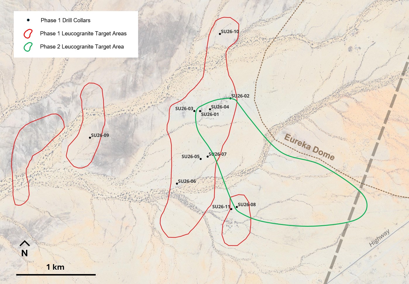
Figure 1: Drill collar locations.
To view an enhanced version of this graphic, please visit:
https://images.newsfilecorp.com/files/6102/317492_c9c7d69804855bb4_001full.jpg
Two Uranium Target Types within a Broad Exploration Area
The expansive target area was first outlined in the Company's November 12, 2025 news release. Government airborne data identified a high-uranium, low-thorium anomaly extending approximately 6.5 by 3.5 kilometres southwest of the Eureka Dome. The target lies along Namibia's Alaskite Alley structural corridor, where leucogranite intrusions are associated with major uranium deposits. At Eureka, the exploration model focuses on these leucogranites and their contacts with surrounding rocks beneath shallow cover.
The December 12, 2025 release reported ground radiometric surveys, soil geochemistry and geological mapping across four grids that strengthened the case for drilling. The maiden drilling program ("Phase 1") then tested selected targets and intersected multiple leucogranite units in all eleven holes, as reported on April 9, 2026. The downhole gamma results, reported herein, add supporting evidence to that sequence of work.
1. Leucogranite and Contact Targets in Bedrock
Repeated gamma responses in leucogranite and adjoining chemically favorable rocks from Phase 1 drilling support Eureka's potential for a large leucogranite-hosted uranium system. This setting shares features with Rössing-style deposits, where leucogranite intrusions and their interaction with surrounding rocks help concentrate uranium.
SU26-01, SU26-04 and SU26-08, which returned the stronger responses at depth, were drilled from sites up to approximately 1.3 kilometres apart. These results identify several areas for follow-up within Eureka's broader target footprint. Continuity between the intersections and the dimensions of mineralization remain unconfirmed.
The Phase 1 results also highlight the importance of rock contacts. SU26-01's 1.5-metre composite crosses leucogranite and calc-silicate schist. In SU26-08, the 16.7-metre composite includes both leucogranite and mica schist, with intervals of 1.2 metres averaging 218.2 ppm eU₃O₈ in mica schist and 1.0 metre averaging 182.6 ppm eU₃O₈ in leucogranite. These associations warrant further exploration of the granite bodies and their contacts, particularly with mica-rich and graphite-bearing schists in the southeastern area.
2. Shallow Calcrete and Gypcrete Targets
The second target is uranium in near-surface calcrete, gypcrete and associated weathered bedrock. Current and historical work recorded carnotite, a secondary uranium mineral, in these materials. This shallow target can be evaluated separately from the covered leucogranite sheets and warrants further investigation of its extent, thickness and uranium distribution.
The new logs provide supporting shallow responses: SU26-09 returned 6.5 metres at 91.0 ppm eU₃O₈ from 1.05 metres across calcrete and calc-silicate schist, while SU26-06 includes 0.6 metre at 143.3 ppm from 1.35 metres entirely within logged gypcrete.
Historical pitting and shallow drilling on former EPL 3637 documented carnotite in overburden and weathered bedrock. R.R. Wartha's December 18, 2009 Annual Technical Report for Ancash Investment (Pty) Ltd., prepared for Valencia Uranium (Pty) Ltd., reported a historical estimate of approximately 3.9 million tonnes at 70 ppm U₃O₈, containing approximately 600,000 lb U₃O₈, in three portions of the Sukses target. The estimate was based on pitting and drilling over 1.5 million square metres and an assumed mineralized thickness of 1–2 metres.
A Qualified Person has not done sufficient work to classify this historical estimate as current mineral resources or mineral reserves, and the Company is not treating it as current mineral resources or mineral reserves.
The estimate supports further investigation of shallow uranium targets but is preliminary and has no stated CIM resource classification. It cannot be equated with an inferred, indicated or measured mineral resource. Supporting records are incomplete, and density, cut-off and quality-control details are not documented in the available report. The estimate's exact location relative to current Eureka licence boundaries also requires verification.
Resource verification would require checking historical locations and records, mapping, additional sampling and drilling, density measurements and geological modelling before a current mineral resource could be estimated.
Next Steps
The encouraging results in SU26-01, SU26-04 and SU26-08 from Phase 1 drilling warrant further exploration southeast of the Eureka Dome, with particular attention to areas closer to the dome margin (see Figure 1). This area is characterized by increased wind-blown sand cover which would mask radiometric signal from blind mineralized leucogranite bodies. Follow-up work during Phase 2 drilling should focus on identifying and testing leucogranite intrusions and their contacts with surrounding rocks in this area.
A high-resolution ground magnetic survey is warranted, prior to Phase 2 drilling, to help identify areas with greater concentrations of leucogranite and potential contacts with chemically favourable host rocks. Integrating the magnetic interpretation with Phase 1 downhole gamma results, geological logging, surface mapping and geochemical data would help refine targets for additional drilling.
Work is progressing to obtain the original historical exploration data focused on shallow calcrete and gypcrete targets, including drilling, pitting, sampling and mapping records. These records will help verify historical target locations and better assess the shallow uranium potential. Combined with further mapping of calcrete, gypcrete and associated uranium occurrences, this work will guide targeted shallow sampling and drilling.
Technical Disclosure
The downhole surveys used a calibrated LIM DEV gamma probe, serial number 1620. Gamma measurements were reported at 0.1-metre depth increments. Raw counts were corrected for detector dead time, using a four-microsecond parameter, and borehole-water attenuation where applicable, before conversion to eU₃O₈. A repeat log of SU26-05 was provided for comparison with the original survey. Processing assumed no radon gas in the drillholes.
The eU₃O₈ values in this release are derived from the numerical downhole logging records and represent radiometric estimates rather than direct chemical measurements. Gamma logging measures radiation, including emissions from uranium's decay products. Where uranium and its decay products are not in balance—a condition known as radioactive disequilibrium—the estimated uranium concentration may differ from the uranium actually present. Instrument calibration, borehole conditions and contributions from other radioactive elements can also affect interpretation.
Reported intervals represent downhole lengths; true widths have not been determined. These exploration results do not establish mineral resources or economic viability.
Qualified Person
Tolene Kruger, BSc. (Hons), M.Sc., is a consulting geologist and has reviewed and approved the scientific and technical information in this news release. Ms. Kruger is a Professional Natural Scientist (Pr.Sci.Nat.) registered with the South African Council for Natural Science Professions (SACNASP, Reg. No. 148182). Ms. Kruger is a Qualified Person for the purposes of National Instrument 43-101 – Standards of Disclosure for Mineral Projects and is not independent of the Company.
About ReeXploration Inc
ReeXploration (TSXV: REE) (FSE: K2I0) is a Canadian exploration company advancing the Eureka Project in central Namibia. Eureka combines rare earth exploration, supported by the production of a clean monazite concentrate, with uranium exploration in an established uranium region. The Company is evaluating both opportunities through geological work and targeted exploration.
Caution Regarding Forward-Looking Information
This news release contains forward-looking information, including statements about sampling priorities, geological interpretations, target evaluation and follow-up exploration. These statements are based on current expectations and assumptions, including the availability of funding, access and technical personnel, and are subject to risks and uncertainties. Actual results may differ materially, including if further work changes the interpretation of the gamma data or geological targets, or if planned work is delayed or cannot be completed. The Company does not undertake to update forward-looking information except as required by applicable securities laws. Further information on risks and uncertainties is included in the Company's filings at www.sedarplus.ca.
Neither the TSX Venture Exchange nor its Regulation Services Provider (as that term is defined in policies of the TSX Venture Exchange) accepts responsibility for the adequacy or accuracy of this release.

To view the source version of this press release, please visit https://www.newsfilecorp.com/release/317492
Source: ReeXploration Inc.
© 2026 Newsfile Corp. All rights reserved.